Hōko Prefecture
| Hōko Prefecture 澎湖廳 | |
|---|---|
| Hōko-chō | |
| 1895-1952 | |
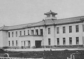 The Hōko Prefecture government building now serves as the Penghu County Government building. | |
| Population | |
• 1941 | 69,387 |
| Historical era | Taiwan under Japanese rule |
• Established | 1895 |
• Disestablished | 25 October 1945 |
| 28 April 1952 | |
| Political subdivisions | 2 subprefectures (支廳) |
| Today part of | Penghu County |
| Hōko Prefecture | |||||||||||||||||
|---|---|---|---|---|---|---|---|---|---|---|---|---|---|---|---|---|---|
| Traditional Chinese | 澎湖廳 | ||||||||||||||||
| Simplified Chinese | 澎湖厅 | ||||||||||||||||
| |||||||||||||||||
Hōko Prefecture (澎湖廳, Hōko-chō) was one of the administrative divisions of Taiwan during the Japanese ruling period from 1895 until 1945. The prefecture consisted of modern-day Penghu County.
Population
| Total population | 69,387 |
|---|---|
| Japanese | 3,619 |
| Taiwanese | 65,694 |
| Korean | 74 |
| 1941 (Showa 16) census. | |
Administrative divisions
Subprefectures
Before its dissolution in 1945 (Shōwa 20), Hōko Prefecture consisted of 2 subprefectures.[1]
| Subprefectures (支廳 shichō) | ||
|---|---|---|
| Name | Kanji | Kana |
| Makō Subprefecture | 馬公支廳 | まこうしちょう |
| Mōan Subprefecture | 望安支廳 | もうあんしちょう |
Towns and Villages
The districts were divided into towns (街) and villages (庄)
| District | Name | Kanji | Notes |
|---|---|---|---|
| Makō 馬公支廳 |
Makō town | 馬公街 | Today Magong City |
| Kosei village | 湖西庄 | Today Huxi Township | |
| Hakusa village | 白沙庄 | Today Baisha Township | |
| Seisho village | 西嶼庄 | Today Xiyu Township | |
| Mōan 望安支廳 |
Mōan village | 望安庄 | Today Wang'an Township |
| Taisho village | 大嶼庄 | Today Cimei Township |
See also
- Administrative divisions of Taiwan
- Governor-General of Taiwan
- Political divisions of Taiwan (1895–1945)
- Taiwan under Japanese rule
References
- ^ 王, 世慶 (1991-06-30). 重修臺灣省通志.卷七:政治志建置沿革篇 (in Chinese). 國史館臺灣文獻館. p. 315.