Hředle (Beroun District)
Hředle | |
|---|---|
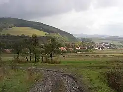 Southern part of Hředle with Homole Hill | |
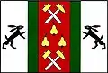 Flag 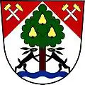 Coat of arms | |
 Hředle Location in the Czech Republic | |
| Coordinates: 49°54′14″N 13°55′14″E / 49.90389°N 13.92056°E | |
| Country | |
| Region | Central Bohemian |
| District | Beroun |
| First mentioned | 1336 |
| Area | |
• Total | 12.35 km2 (4.77 sq mi) |
| Elevation | 238 m (781 ft) |
| Population (2025-01-01)[1] | |
• Total | 399 |
| • Density | 32/km2 (84/sq mi) |
| Time zone | UTC+1 (CET) |
| • Summer (DST) | UTC+2 (CEST) |
| Postal code | 267 51 |
| Website | www |
Hředle is a municipality and village in Beroun District in the Central Bohemian Region of the Czech Republic. It has about 400 inhabitants.
Demographics
| Year | Pop. | ±% |
|---|---|---|
| 1869 | 605 | — |
| 1880 | 598 | −1.2% |
| 1890 | 604 | +1.0% |
| 1900 | 669 | +10.8% |
| 1910 | 665 | −0.6% |
| 1921 | 667 | +0.3% |
| 1930 | 652 | −2.2% |
| 1950 | 478 | −26.7% |
| 1961 | 416 | −13.0% |
| 1970 | 408 | −1.9% |
| 1980 | 372 | −8.8% |
| 1991 | 309 | −16.9% |
| 2001 | 307 | −0.6% |
| 2011 | 384 | +25.1% |
| 2021 | 401 | +4.4% |
| Source: Censuses[2][3] | ||
References
- ^ "Population of Municipalities – 1 January 2025". Czech Statistical Office. 2025-05-16.
- ^ "Historický lexikon obcí České republiky 1869–2011" (in Czech). Czech Statistical Office. 2015-12-21.
- ^ "Population Census 2021: Population by sex". Public Database. Czech Statistical Office. 2021-03-27.
External links
Wikimedia Commons has media related to Hředle (Beroun District).