Halen
Halen | |
|---|---|
City and municipality | |
_(21764)_18-08-2019.jpg) | |
 Flag 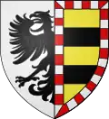 Coat of arms | |
Location of Halen | |
 Halen Location in Belgium
Location of Halen in Limburg 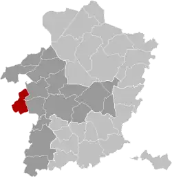 | |
| Coordinates: 50°56′53″N 05°06′52″E / 50.94806°N 5.11444°E | |
| Country | Belgium |
| Community | Flemish Community |
| Region | Flemish Region |
| Province | |
| Arrondissement | Hasselt |
| Government | |
| • Mayor | Erik Van Roelen (CD&V) |
| • Governing party/ies | CD&V |
| Area | |
• Total | 36.6 km2 (14.1 sq mi) |
| Population (2018-01-01)[1] | |
• Total | 9,461 |
| • Density | 260/km2 (670/sq mi) |
| Postal codes | 3545 |
| NIS code | 71020 |
| Area codes | 013 |
| Website | www.halen.be |
Halen (Dutch pronunciation: [ˈɦaːlə(n)] ⓘ), formerly Haelen (Limburgish: Hôle), is a municipality and city[2] located in the Belgian province of Limburg, to the west of Hasselt. On January 1, 2018, Halen had a total population of 9,461. The total area is 36.29 km2 which gives a population density of 261 inhabitants per km2.
The municipality consists of the following sub-municipalities: Halen proper, Loksbergen, and Zelem.
During the First World War, on August 12, 1914, the Battle of Halen took place here near the river crossing of the Gete.
References
- ^ "Wettelijke Bevolking per gemeente op 1 januari 2018". Statbel. Retrieved 9 March 2019.
- ^ "Wet tot toekenning van de titel van stad aan de gemeenten Beringen, Bilzen, Blankenberge, Borgloon, Ciney, Couvin, Damme, Geel, Genepiën, Gistel, Halen, Hamont-Achel, Hannuit, Harelbeke, Herk-de-Stad, Lo-Reninge, Mesen, Oudenburg, Peer, Scherpenheuvel-Zichem, Vilvoorde en Walcourt". www.ejustice.just.fgov.be (in Dutch). Belgian Official Gazette. 19 July 1985. Retrieved 22 April 2025.
External links
 Media related to Halen at Wikimedia Commons
 Halen travel guide from Wikivoyage
- (in Dutch) Official website
Places adjacent to Halen | ||||||||||||||||
|---|---|---|---|---|---|---|---|---|---|---|---|---|---|---|---|---|
| ||||||||||||||||
| Hasselt | 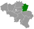 | |
|---|---|---|
| Maaseik | ||
| Tongeren | ||
| ||