Hammonville, Kentucky
Hammonville, Kentucky | |
|---|---|
 Hammonville  Hammonville | |
| Coordinates: 37°24′53″N 85°47′51″W / 37.41472°N 85.79750°W | |
| Country | United States |
| State | Kentucky |
| County | Hart |
| Elevation | 712 ft (217 m) |
| Time zone | UTC-6 (Central (CST)) |
| • Summer (DST) | UTC-5 (CDT) |
| Area codes | 270 & 364 |
| GNIS feature ID | 508169[1] |
Hammonville (also Hammonsville) is an unincorporated community in Hart County, Kentucky, in the United States.
History
Hammonville was named for an early resident.[2]
References
- ^ "Hammonville". Geographic Names Information System. United States Geological Survey, United States Department of the Interior.
- ^ Gannett, Henry (1905). The Origin of Certain Place Names in the United States. Govt. Print. Off. pp. 148.
Municipalities and communities of Hart County, Kentucky, United States | ||
|---|---|---|
| Cities | 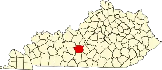 | |
| CDP | ||
| Other unincorporated communities | ||