Harrat Rahat
| Harrat Rahat | |
|---|---|
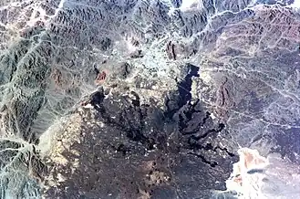 Satellite picture of the northern part of the lava field | |
| Highest point | |
| Elevation | 1,744 m (5,722 ft) |
| Coordinates | 23°5′0″N 39°47′0″E / 23.08333°N 39.78333°E |
| Naming | |
| Native name | حَرَّة رَهَاط (Arabic) |
| Geography | |
| Location | Hejaz, Saudi Arabia |
| Geology | |
| Mountain type | Volcanic field |
| Last eruption | June to July 1256 |
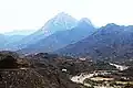
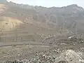
Ḥarrat Rahāṭ[1] (Arabic: حَرَّة رَهَاط) is a volcanic lava field in the Hejazi region of Saudi Arabia. In 1256 CE, a 0.5 km3 (0.12 cu mi) lava flow erupted from six aligned scoria cones, and traveled 23 km (14 miles) to within 4 km (2.5 miles) of the Islamic holy city of Medina; this was its last eruption. There were earlier eruptions, such as in 641 CE, which made finger-like flows to the east of the 1256 CE flow.[2] It is the biggest lava field in Saudi Arabia.[3] Nearby is Al Wahbah crater.
There has been recent increase in seismic activity since 2009.[4]
See also
External links
References
- ^ "Harrat Rahat". Global Volcanism Program. Smithsonian Institution.
- ^ "Living on Lava". 25 February 2019.
- ^ Brown, Glen F.; Schmidt, Dwight L.; Huffman, A. Curtis Jr. (1989). "Geology of the Arabian Peninsula; shield area of western Saudi Arabia". doi:10.3133/pp560A.
{{cite journal}}: Cite journal requires|journal=(help) - ^ Moufti, Mohammed Rashad; Németh, Károly (2016), "Harrat Rahat: The Geoheritage Value of the Youngest Long-Lived Volcanic Field in the Kingdom of Saudi Arabia", Geoheritage of Volcanic Harrats in Saudi Arabia, Cham: Springer International Publishing, pp. 33–120, doi:10.1007/978-3-319-33015-0_3, ISBN 978-3-319-33013-6, retrieved 2022-05-12
Hills and mountains on the Arabian Peninsula | |
|---|---|
Note: Mountains are sorted in alphabetical order, unless where it concerns ranges. The highest confirmed mountains in each country are indicated with 'HP', and those with the highest peak are indicated with 'HP', bearing in mind that in the UAE, the highest mountain and the mountain with the highest peak are different. Outcrops are indicated with 'OC', and outliers with 'OL', and anticlines with 'AC'. Volcanoes are indicated with 'V', volcanic craters with 'VC', lava fields with 'LF', and volcanic fields with 'VF'.
Other notes:
|
.jpg)
.jpg)