Harris, North Carolina
Harris, North Carolina | |
|---|---|
 Harris  Harris | |
| Coordinates: 35°14′34″N 81°52′28″W / 35.24278°N 81.87444°W | |
| Country | United States |
| State | North Carolina |
| County | Rutherford |
| Elevation | 791 ft (241 m) |
| Time zone | UTC-5 (Eastern (EST)) |
| • Summer (DST) | UTC-4 (EDT) |
| ZIP code | 28074 |
| Area code | 828 |
| GNIS feature ID | 1024024[1] |
Harris is an unincorporated community in Rutherford County, North Carolina, United States. The community is located along a railroad south of U.S. Route 221 and 10 miles (16 km) south-southeast of Rutherfordton. Harris has a post office with ZIP code 28074.[2][3]
References
- ^ "Harris". Geographic Names Information System. United States Geological Survey, United States Department of the Interior.
- ^ United States Postal Service (2012). "USPS - Look Up a ZIP Code". Retrieved February 6, 2015.
- ^ "Postmaster Finder - Post Offices by ZIP Code". United States Postal Service. Archived from the original on October 17, 2020. Retrieved February 6, 2015.
Municipalities and communities of Rutherford County, North Carolina, United States | ||
|---|---|---|
| Towns | 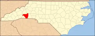 | |
| Village | ||
| CDPs | ||
| Unincorporated communities | ||