Hartland (CDP), Vermont
Hartland, Vermont | |
|---|---|
 War Memorial | |
_highlighted.svg.png) Location in Windsor County and the state of Vermont. | |
| Coordinates: 43°32′36″N 72°23′56″W / 43.54333°N 72.39889°W | |
| Country | United States |
| State | Vermont |
| County | Windsor |
| Area | |
• Total | 1.1 sq mi (2.8 km2) |
| • Land | 1.1 sq mi (2.8 km2) |
| • Water | 0.0 sq mi (0.0 km2) |
| Elevation | 587 ft (179 m) |
| Population (2010) | |
• Total | 380 |
| • Density | 350/sq mi (140/km2) |
| Time zone | UTC-5 (Eastern (EST)) |
| • Summer (DST) | UTC-4 (EDT) |
| ZIP code | 05048 |
| Area code | 802 |
| FIPS code | 50-32350[1] |
| GNIS feature ID | 1457747[2] |
Hartland is a census-designated place (CDP) that comprises the central village of the town of Hartland, Windsor County, Vermont, United States. As of the 2010 census, the population of the CDP was 380,[3] compared to 3,393 for the entire town of Hartland.
Geography
Hartland is located at the intersection of U.S. Route 5 and Vermont Route 12 in eastern Windsor County. Route 12 travels north to Woodstock, while Route 5 heads north to White River Junction. The two roads travel south in a concurrency to Windsor. Interstate 91 passes east of the village, with access via Exit 9.
References
- ^ "U.S. Census website". United States Census Bureau. Retrieved January 31, 2008.
- ^ "US Board on Geographic Names". United States Geological Survey. October 25, 2007. Retrieved January 31, 2008.
- ^ "Profile of General Population and Housing Characteristics: 2010 Demographic Profile Data (DP-1): Hartland CDP, Vermont". United States Census Bureau. Retrieved August 1, 2012.
Municipalities and communities of Windsor County, Vermont, United States | ||
|---|---|---|
| Towns | 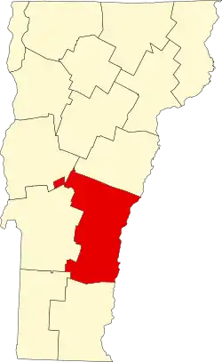 | |
| Villages | ||
| CDPs | ||
| Other communities | ||