Haut-Katanga Province
Haut-Katanga
| |
|---|---|
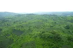 Hills in Katanga during the rainy season | |
 Seal | |
_-_Haut-Katanga.svg.png) | |
| Coordinates: 11°40′S 27°29′E / 11.667°S 27.483°E | |
| Country | |
| Established | 2015 |
| Capital and largest city | Lubumbashi |
| Government | |
| • Governor | Jacques Kyabula[1] |
| Area | |
• Total | 132,425 km2 (51,130 sq mi) |
| • Rank | 5th |
| Population (2020) | |
• Total | 5,718,800 |
| • Rank | 6th |
| • Density | 43/km2 (110/sq mi) |
| Ethnic groups | |
| • Native | Lamba, Lala, Aushi, AbaBemba, Kaonde, Nwenshi, Lomotwa, Zela, Garanganze(BaYeke), Taabwa, Sanga |
| Time zone | UTC+2 (CAT) |
| License Plate Code | |
| Official language | French |
| National language | Kiswahili |
| Website | www |
Haut-Katanga (French for "Upper Katanga") is one of the 21 provinces of the Democratic Republic of the Congo created in the 2015 repartitioning. Haut-Katanga, Haut-Lomami, Lualaba, and Tanganyika provinces are the result of the dismemberment of the former Katanga province.[2] Haut-Katanga was formed from the Haut-Katanga district and the independently administered cities of Likasi and Lubumbashi. Lubumbashi retained its status as a provincial capital, and as of 2020, it had an estimated population of 5,718,800.[3]
The new province's territory corresponds to the historic Katanga-Oriental that existed in the early period after independence between 1963 and 1966.
Along with Lualaba, Haut-Katanga is in the Copperbelt of Central Africa.[4] The DRC is only behind Chile, Peru, and the PRC in largest amount of copper produced globally.
Administrative divisions

Haut-Katanga is divided into 6 territories and 2 cities.
Territories:
Cities:
Approximate correspondence between historical and current province
| Belgian Congo | Republic of the Congo | Zaire | Democratic Republic of the Congo | ||||||
|---|---|---|---|---|---|---|---|---|---|
| 1908 | 1919 | 1932 | 1947 | 1963 | 1966 | 1971 | 1988 | 1997 | 2015 |
| 22 districts | 4 provinces | 6 provinces | 6 provinces | 21 provinces + capital | 8 provinces + capital | 8 provinces + capital | 11 provinces | 11 provinces | 26 provinces |
| Tanganika-Moero | Katanga | Élisabethville | Katanga | Nord-Katanga | Katanga | Shaba | Katanga | Tanganyika | |
| Haut-Lomami | |||||||||
| Lulua | Lualaba | Lualaba | |||||||
| Haut-Luapula | Katanga-Oriental | Haut-Katanga | |||||||
| Lomami | Lusambo | Kasaï | Lomami | Kasaï-Oriental | Lomami | ||||
References
- ^ Lukusa, Patient (11 July 2024). "Haut-Katanga : Le gouvernement provincial investi". 7sur7.cd (in French). Retrieved 14 July 2024.
- ^ "Le Katanga officiellement démembré en quatre nouvelles provinces". Radio Okapi (in French). 16 July 2015. Archived from the original on 19 July 2015. Retrieved 8 June 2020.
- ^ "Congo (Dem. Rep.): Provinces, Major Cities & Towns - Population Statistics, Maps, Charts, Weather and Web Information". www.citypopulation.de. Archived from the original on 2022-06-26. Retrieved 2024-02-11.
- ^ "Mining Analyst visit to the DRC" (PDF). Metorex. Archived from the original (PDF) on 25 April 2012. Retrieved 7 July 2025.