Heinsdorfergrund
Heinsdorfergrund | |
|---|---|
 Coat of arms | |
Location of Heinsdorfergrund within Vogtlandkreis district 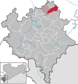 | |
 Heinsdorfergrund  Heinsdorfergrund | |
| Coordinates: 50°37′20″N 12°22′20″E / 50.62222°N 12.37222°E | |
| Country | Germany |
| State | Saxony |
| District | Vogtlandkreis |
| Subdivisions | 3 |
| Area | |
• Total | 21.86 km2 (8.44 sq mi) |
| Elevation | 380 m (1,250 ft) |
| Population (2023-12-31)[1] | |
• Total | 1,931 |
| • Density | 88/km2 (230/sq mi) |
| Time zone | UTC+01:00 (CET) |
| • Summer (DST) | UTC+02:00 (CEST) |
| Postal codes | 08468 |
| Dialling codes | 03765,037600 |
| Vehicle registration | V, AE, OVL, PL, RC |
| Website | www.heinsdorfergrund-vogtland.de |
Heinsdorfergrund (German pronunciation: [ˈhaɪnsdɔʁfɐˌɡʁʊnt] ⓘ) is a municipality in the Vogtlandkreis district, in Saxony, Germany. The municipality was first mentioned in 1323 as Heinrichesdorf.
References