Hermandad de Campoo de Suso
Hermandad de Campoo de Suso | |
|---|---|
 Flag  Coat of arms | |
_Mapa.svg.png) Location of Hermandad de Campoo de Suso | |
 Hermandad de Campoo de Suso Location in Spain | |
| Coordinates: 43°1′21″N 4°13′28″W / 43.02250°N 4.22444°W | |
| Country | |
| Autonomous community | |
| Province | Cantabria |
| Comarca | Campoo |
| Judicial district | Reinosa |
| Government | |
| • Mayor | Pedro Luis Gutiérrez González (2007) (PP) |
| Area | |
• Total | 222.65 km2 (85.97 sq mi) |
| Elevation | 886 m (2,907 ft) |
| Population (2018)[1] | |
• Total | 1,627 |
| • Density | 7.3/km2 (19/sq mi) |
| Time zone | UTC+1 (CET) |
| • Summer (DST) | UTC+2 (CEST) |
Hermandad de Campoo de Suso is a municipality located in the autonomous community of Cantabria, Spain. The municipality's seat is in Espinilla.
The Ebro River rises in this municipality, in the town of Fontibre.
Towns
- Abiada
- Argüeso
- Barrio
- Camino
- Celada de los Calderones
- Entrambasaguas
- Espinilla (capital)
- Fontibre
- Hoz de Abiada
- Izara
- La Lomba
- Mazandrero
- La Miña
- Naveda
- Ormas
- Paracuelles
- Población de Suso
- Proaño
- Salces
- La Serna
- Soto
- Suano
- Villacantid
- Villar
References
- ^ Municipal Register of Spain 2018. National Statistics Institute.
External links
- Hermandad de Campoo de Suso - Cantabria 102 Municipios
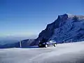
Gallery
-
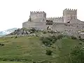 San Vicente Castle, in Argüeso, Hermandad de Campoo de Suso. Dates from the end of the 13th century till the 15th century.
 -
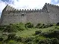 Wall surrounding the San Vicente Castle.
 -
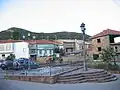 Fontibre village.
 -
-
 Feast of the Campanos, campurrians with their typical dresses.