Hintere Schwärze
| Hintere Schwärze | |
|---|---|
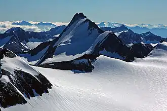 Hintere Schwarze in summer 2005 | |
| Highest point | |
| Elevation | 3,628 m (11,903 ft) |
| Prominence | 805 m (2,641 ft) |
| Parent peak | Weißkugel (Wildspitze) |
| Listing | Alpine mountains above 3000 m |
| Coordinates | 46°46′24″N 10°54′53″E / 46.77333°N 10.91472°E |
| Geography | |
| Location | Tyrol, Austria / South Tyrol, Italy |
| Parent range | Ötztal Alps |
| Climbing | |
| First ascent | 10 Sep 1867 by E. Pfeiffer, B. Klotz, J. Scheiber |
| Easiest route | Glacier ascent over the west flank |

Hintere Schwärze
Location in Austria
Hintere Schwärze (Austrian German pronunciation: [ˈhɪntərɛ ˈʃvɛrtsɛ] ⓘ; Italian: Cima Nera) is a mountain on the border between Austria and Italy. At 3,628 metres (11,903 ft), it is the fourth highest peak in the Ötztal Alps.[1][2]
References
- ^ "Hintere Schwarze".
- ^ Klier, Walter (2006). Ötztaler Alpen. Bergverlag Rother. ISBN 978-3-7633-1123-1.