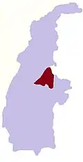
Hmangin, Banmauk
Hmangin | |
|---|---|
Village | |
 Hmangin Location in Burma | |
| Coordinates: 24°11′N 95°54′E / 24.183°N 95.900°E | |
| Country | |
| Region | Sagaing Region |
| District | Katha District |
| Township | Banmauk Township |
| Time zone | UTC+6.30 (MST) |
Hmangin is a village in Banmauk Township, Katha District, in the Sagaing Region of northern-central Burma.[1]
| Type: | Populated place - a city, town, village, or other agglomeration of buildings where people live and work |
|---|---|
| Mindat.org Region: | Homalin Township, Hkamti District, Sagaing Region, Myanmar |
| Region: | Homalin, Hkamti District, Sagaing Region, Myanmar |
| Latitude: | 24° 42' 11" N |
| Longitude: | 94° 55' 18" E |
| Lat/Long (dec): | 24.70319,94.92172 |
| Köppen climate type: | Cwa : Monsoon-influenced humid subtropical climate |
| Mindat Feature ID: | 1324412 |
| Long-form Identifier: | mindat:2:6:1324412:7 |
| GUID: | 6ba85bae-65fb-44fe-88e6-03cab1fa43a9 |