Holcombe, Wisconsin
Holcombe, Wisconsin | |
|---|---|
Census-designated place | |
 Holcombe | |
| Coordinates: 45°13′28″N 91°07′03″W / 45.22444°N 91.11750°W | |
| Country | United States |
| State | Wisconsin |
| County | Chippewa |
| Town | Lake Holcombe |
| Area | |
• Total | 0.967 sq mi (2.50 km2) |
| • Land | 0.967 sq mi (2.50 km2) |
| • Water | 0 sq mi (0 km2) |
| Elevation | 1,047 ft (319 m) |
| Population | |
• Total | 239 |
| • Density | 250/sq mi (95/km2) |
| Time zone | UTC-6 (Central (CST)) |
| • Summer (DST) | UTC-5 (CDT) |
| ZIP code | 54745 |
| Area codes | 715 & 534 |
| GNIS feature ID | 1566537[2] |
Holcombe is a census-designated place located in Chippewa County, Wisconsin, United States.
Description
| Census | Pop. | Note | %± |
|---|---|---|---|
| 2010 | 267 | — | |
| 2020 | 239 | −10.5% |
Holcombe is located on the Chippewa River north-northeast of Cornell, in the town of Lake Holcombe. Holcombe has a post office with ZIP code 54745.[3] As of the 2010 census, its population was 267.[4]
History
Holcombe was founded in 1902.[5] It was named for an acquaintance of a railroad official.[5] A post office has been in operation in Holcombe since 1902.[6]
Climate
| Climate data for Holcombe, Wisconsin (1991–2020 normals, extremes 1942–present) | |||||||||||||
|---|---|---|---|---|---|---|---|---|---|---|---|---|---|
| Month | Jan | Feb | Mar | Apr | May | Jun | Jul | Aug | Sep | Oct | Nov | Dec | Year |
| Record high °F (°C) | 53 (12) |
60 (16) |
81 (27) |
90 (32) |
94 (34) |
95 (35) |
99 (37) |
100 (38) |
95 (35) |
89 (32) |
75 (24) |
62 (17) |
100 (38) |
| Mean daily maximum °F (°C) | 22.3 (−5.4) |
27.6 (−2.4) |
39.1 (3.9) |
53.5 (11.9) |
66.2 (19.0) |
75.1 (23.9) |
79.6 (26.4) |
77.4 (25.2) |
69.6 (20.9) |
56.1 (13.4) |
39.9 (4.4) |
27.7 (−2.4) |
52.8 (11.6) |
| Daily mean °F (°C) | 12.3 (−10.9) |
16.5 (−8.6) |
28.7 (−1.8) |
42.9 (6.1) |
55.3 (12.9) |
64.7 (18.2) |
69.1 (20.6) |
66.9 (19.4) |
58.8 (14.9) |
45.9 (7.7) |
31.9 (−0.1) |
19.7 (−6.8) |
42.7 (5.9) |
| Mean daily minimum °F (°C) | 2.3 (−16.5) |
5.5 (−14.7) |
18.3 (−7.6) |
32.3 (0.2) |
44.5 (6.9) |
54.3 (12.4) |
58.7 (14.8) |
56.4 (13.6) |
47.9 (8.8) |
35.8 (2.1) |
23.8 (−4.6) |
11.6 (−11.3) |
32.6 (0.3) |
| Record low °F (°C) | −44 (−42) |
−45 (−43) |
−40 (−40) |
1 (−17) |
20 (−7) |
27 (−3) |
36 (2) |
32 (0) |
17 (−8) |
11 (−12) |
−16 (−27) |
−39 (−39) |
−45 (−43) |
| Average precipitation inches (mm) | 1.03 (26) |
1.02 (26) |
1.72 (44) |
3.01 (76) |
3.86 (98) |
4.71 (120) |
3.87 (98) |
4.26 (108) |
3.67 (93) |
3.04 (77) |
1.85 (47) |
1.29 (33) |
33.33 (847) |
| Source: NOAA[7][8] | |||||||||||||
References
- ^ "Census Bureau profile: Holcombe CDP, Wisconsin". United States Census Bureau. May 2023. Retrieved November 6, 2024.
- ^ "US Board on Geographic Names". United States Geological Survey. October 25, 2007. Retrieved January 31, 2008.
- ^ ZIP Code Lookup
- ^ "U.S. Census website". U.S. Census Bureau. Retrieved April 5, 2011.
- ^ a b Chicago and North Western Railway Company (1908). A History of the Origin of the Place Names Connected with the Chicago & North Western and Chicago, St. Paul, Minneapolis & Omaha Railways. p. 178.
- ^ "Chippewa County". Jim Forte Postal History. Retrieved April 4, 2015.
- ^ "NOWData - NOAA Online Weather Data". National Oceanic and Atmospheric Administration. Retrieved March 27, 2024.
- ^ "Summary of Monthly Normals 1991-2020". National Oceanic and Atmospheric Administration. Retrieved March 27, 2024.
Municipalities and communities of Chippewa County, Wisconsin, United States | ||
|---|---|---|
| Cities | 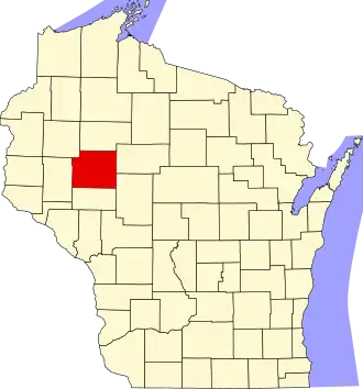 | |
| Villages | ||
| Towns | ||
| CDPs | ||
| Unincorporated communities | ||
| Footnotes | ‡This populated place also has portions in an adjacent county or counties | |