Homla
| Homla | |
|---|---|
Interactive map of the river | |
| Location | |
| Country | Norway |
| County | Trøndelag |
| Municipality | Malvik Municipality |
| Physical characteristics | |
| Source | Foldsjøen |
| • location | Malvik Municipality, Norway |
| • coordinates | 63°20′25″N 10°46′50″E / 63.34028°N 10.78056°E |
| • elevation | 205 metres (673 ft) |
| Mouth | Trondheimsfjord, Hommelvik |
• location | Malvik Municipality, Norway |
• coordinates | 63°24′38″N 10°47′39″E / 63.41056°N 10.79417°E |
• elevation | 0 metres (0 ft) |
| Length | 10 km (6.2 mi) |
| Basin size | 156.3 km2 (60.3 sq mi) |
| Discharge | |
| • average | 2.94 m3/s (104 cu ft/s) |
| Basin features | |
| Tributaries | |
| • right | Nævra |
Homla[1] is a river in Malvik Municipality in Trøndelag county, Norway. The 10-kilometre (6.2 mi) long river begins when it flows out of the lake Foldsjøen and it ends when it empties into the Trondheimsfjorden at the village of Hommelvik.[2]
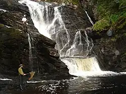
The Homla was first used by the timber industry to transport recently cut trees, but it is now just a small river with good fishing opportunities. Small-sized salmon and sea trout can be caught here.
Around the year 2000, there were plans for constructing a large dam over the river's largest waterfall, "Storfossen". Due to local opposition, these plans were eventually aborted.
See also
References
- ^ "Informasjon om stadnamn". Norgeskart (in Norwegian). Kartverket. Retrieved 2025-02-06.
- ^ "Homla" (in Norwegian). yr.no. Retrieved 2011-03-09.