Honezovice
Honezovice | |
|---|---|
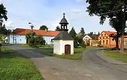 Hradišťany, a part of Honezovice | |
 Flag  Coat of arms | |
 Honezovice Location in the Czech Republic | |
| Coordinates: 49°38′18″N 13°3′45″E / 49.63833°N 13.06250°E | |
| Country | |
| Region | Plzeň |
| District | Plzeň-South |
| First mentioned | 1115 |
| Area | |
• Total | 18.03 km2 (6.96 sq mi) |
| Elevation | 390 m (1,280 ft) |
| Population (2025-01-01)[1] | |
• Total | 279 |
| • Density | 15/km2 (40/sq mi) |
| Time zone | UTC+1 (CET) |
| • Summer (DST) | UTC+2 (CEST) |
| Postal code | 333 01 |
| Website | www |
Honezovice is a municipality and village in Plzeň-South District in the Plzeň Region of the Czech Republic. It has about 300 inhabitants.
Honezovice lies approximately 26 kilometres (16 mi) south-west of Plzeň and 110 km (68 mi) south-west of Prague.
Administrative division
Honezovice consists of two municipal parts (in brackets population according to the 2021 census):[2]
- Honezovice (210)
- Hradišťany (45)
Demographics
| Year | Pop. | ±% |
|---|---|---|
| 1869 | 648 | — |
| 1880 | 643 | −0.8% |
| 1890 | 649 | +0.9% |
| 1900 | 672 | +3.5% |
| 1910 | 753 | +12.1% |
| 1921 | 748 | −0.7% |
| 1930 | 794 | +6.1% |
| 1950 | 448 | −43.6% |
| 1961 | 413 | −7.8% |
| 1970 | 349 | −15.5% |
| 1980 | 272 | −22.1% |
| 1991 | 255 | −6.2% |
| 2001 | 224 | −12.2% |
| 2011 | 224 | +0.0% |
| 2021 | 255 | +13.8% |
| Source: Censuses[3][4] | ||
References
- ^ "Population of Municipalities – 1 January 2025". Czech Statistical Office. 2025-05-16.
- ^ "Public Census 2021 – basic data". Public Database (in Czech). Czech Statistical Office. 2022.
- ^ "Historický lexikon obcí České republiky 1869–2011" (in Czech). Czech Statistical Office. 2015-12-21.
- ^ "Population Census 2021: Population by sex". Public Database. Czech Statistical Office. 2021-03-27.
External links
Wikimedia Commons has media related to Honezovice.