Hoogezand-Sappemeer
Hoogezand-Sappemeer | |
|---|---|
Former municipality | |
|
| |
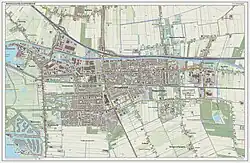
.svg.png) Location in Groningen | |
| Coordinates: 53°9′N 6°45′E / 53.150°N 6.750°E | |
| Country | Netherlands |
| Province | Groningen |
| Municipality | Midden-Groningen |
| Established | 1949 |
| Ceased to exist | 2018 |
| Area | |
• Total | 72.99 km2 (28.18 sq mi) |
| • Land | 66.71 km2 (25.76 sq mi) |
| • Water | 6.28 km2 (2.42 sq mi) |
| Elevation | 2 m (7 ft) |
| Population (January 2021)[3] | |
• Total | data missing |
| Time zone | UTC+1 (CET) |
| • Summer (DST) | UTC+2 (CEST) |
| Postcode | 9600–9614, 9630–9633 |
| Area code | 0598 |
Hoogezand-Sappemeer (Dutch pronunciation: [ɦoːɣəˌzɑnt sɑpəˈmeːr] ⓘ) is a former municipality in the Northeastern Netherlands. It was the third most-populous municipality in the province of Groningen, after Groningen and Oldambt. It was formed in 1949 by the merger of the former municipalities of Hoogezand (well-known for its ship building industry) and Sappemeer. On 1 January 2018, Hoogezand-Sappemeer merged with Slochteren and Menterwolde, forming the new municipality Midden-Groningen.
Geography
Population centres in the municipality were:
- Achterdiep
- Borgercompagnie
- Borgweg
- Foxham
- Foxhol
- Foxholsterbosch
- Hoogezand
- Jagerswijk
- Kalkwijk
- Kiel-Windeweer
- Kleinemeer
- Kropswolde
- Lula
- Martenshoek
- Meerwijck
- Nieuwe Compagnie
- Sappemeer
- Tripscompagnie
- Waterhuizen
- Westerbroek
- Wolfsbarge
Gallery
-
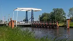 Sappemeer, bridge: the Noordbroeksterbrug
 -
 Sappemeer, church: the Sint-Willibrorduskerk
 -
 Zuidbroek, clock tower from reformed church
 -
 Muntendam, former townhall
 -
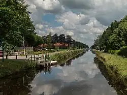 Kiel-Windeweer, view to the hamlet
Transportation
The A7 motorway (European Highway E 22, Amsterdam-Groningen-Germany) crosses the municipality. There is also a railway line providing service to Groningen and Nieuweschans/Leer(Germany). Trains serve four stations in the municipality, Kropswolde, Martenshoek, Hoogezand-Sappemeer, and Sappemeer Oost. Since 2007, trains will stop 4 times an hour.
References
- ^ "Kerncijfers wijken en buurten 2020" [Key figures for neighbourhoods 2020]. StatLine (in Dutch). CBS. 24 July 2020. Retrieved 19 September 2020.
- ^ "Postcodetool for 9603AE". Actueel Hoogtebestand Nederland (in Dutch). Het Waterschapshuis. Archived from the original on 21 September 2013. Retrieved 23 January 2014.
- ^ "Bevolkingsontwikkeling; regio per maand" [Population growth; regions per month]. CBS Statline (in Dutch). CBS. 1 January 2021. Retrieved 2 January 2022.
External links
- Official website
 Media related to Hoogezand-Sappemeer at Wikimedia Commons
Places adjacent to Hoogezand-Sappemeer | ||||||||||||||||
|---|---|---|---|---|---|---|---|---|---|---|---|---|---|---|---|---|
| ||||||||||||||||