Inning am Ammersee
Inning a.Ammersee | |
|---|---|
 Church of Saint John the Baptist | |
 Coat of arms | |
Location of Inning a.Ammersee within Starnberg district 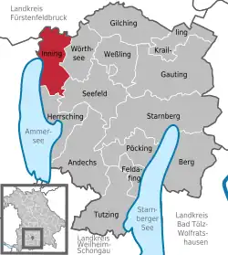 | |
 Inning a.Ammersee  Inning a.Ammersee | |
| Coordinates: 48°04′N 11°09′E / 48.067°N 11.150°E | |
| Country | Germany |
| State | Bavaria |
| Admin. region | Oberbayern |
| District | Starnberg |
| Subdivisions | 6 Ortsteile |
| Government | |
| • Mayor (2020–26) | Walter Bleimaier[1] (CSU) |
| Area | |
• Total | 24.42 km2 (9.43 sq mi) |
| Elevation | 553 m (1,814 ft) |
| Population (2024-12-31)[2] | |
• Total | 4,822 |
| • Density | 200/km2 (510/sq mi) |
| Time zone | UTC+01:00 (CET) |
| • Summer (DST) | UTC+02:00 (CEST) |
| Postal codes | 82266 |
| Dialling codes | 08143 |
| Vehicle registration | STA |
| Website | www.inning.de |
Inning am Ammersee (German pronunciation: [ˈɪnɪŋ ʔam ˈʔamɐˌzeː] ⓘ, lit. 'Inning on the Ammersee') is a municipality in Bavaria, Germany, in the district of Starnberg, in the Regierungsbezirk of Oberbayern. It lies on the shores of lake Ammersee.
References
- ^ Liste der ersten Bürgermeister/Oberbürgermeister in kreisangehörigen Gemeinden, Bayerisches Landesamt für Statistik, 15 July 2021.
- ^ "Gemeinden, Kreise und Regierungsbezirke in Bayern, Einwohnerzahlen am 31. Dezember 2024; Basis Zensus 2022" [Municipalities, counties, and administrative districts in Bavaria; Based on the 2022 Census] (CSV) (in German). Bayerisches Landesamt für Statistik.
Towns and municipalities in Starnberg district | ||
|---|---|---|