Irakleotes
Irakleotes
Ηρακλεώτες | |
|---|---|
 Irakleotes Location within the regional unit 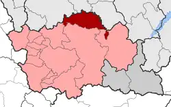 | |
| Coordinates: 40°12′N 21°25′E / 40.200°N 21.417°E | |
| Country | Greece |
| Administrative region | Western Macedonia |
| Regional unit | Grevena |
| Municipality | Grevena |
| Area | |
| • Municipal unit | 136.631 km2 (52.754 sq mi) |
| Elevation | 705 m (2,313 ft) |
| Population (2021)[1] | |
| • Municipal unit | 1,384 |
| • Municipal unit density | 10/km2 (26/sq mi) |
| Time zone | UTC+2 (EET) |
| • Summer (DST) | UTC+3 (EEST) |
| Postal code | 510 30, 511 00 |
| Area code(s) | +30-2462 |
| Vehicle registration | PN |
Irakleotes (Greek: Ηρακλεώτες) is a municipal unit of the Grevena municipality. Before the 2011 local government reform, it was an independent municipality.[2] The seat of the municipality was in Agios Georgios. Irakleotes covers an area of 136.631 km2.[3]
Population
| Year | Pop. | ±% |
|---|---|---|
| 2001[3] | 2,418 | — |
| 2011[4] | 1,890 | −21.8% |
| 2021[1] | 1,384 | −26.8% |
References
- ^ a b "Αποτελέσματα Απογραφής Πληθυσμού - Κατοικιών 2021, Μόνιμος Πληθυσμός κατά οικισμό" [Results of the 2021 Population - Housing Census, Permanent population by settlement] (in Greek). Hellenic Statistical Authority. 29 March 2024.
- ^ "ΦΕΚ B 1292/2010, Kallikratis reform municipalities" (in Greek). Government Gazette.
- ^ a b "Population & housing census 2001 (incl. area and average elevation)" (PDF) (in Greek). National Statistical Service of Greece. Archived from the original (PDF) on 2015-09-21.
- ^ "Απογραφή Πληθυσμού - Κατοικιών 2011. ΜΟΝΙΜΟΣ Πληθυσμός" (in Greek). Hellenic Statistical Authority.