Jersey, Ohio
Jersey, Ohio | |
|---|---|
 Jersey  Jersey | |
| Coordinates: 40°03′21″N 82°43′22″W / 40.05583°N 82.72278°W | |
| Country | United States |
| State | Ohio |
| County | Licking |
| Township | Jersey |
| Area | |
• Total | 1.65 sq mi (4.27 km2) |
| • Land | 1.64 sq mi (4.25 km2) |
| • Water | 0.01 sq mi (0.02 km2) |
| Elevation | 1,129 ft (344 m) |
| Population (2020) | |
• Total | 427 |
| • Density | 260.37/sq mi (100.55/km2) |
| Time zone | UTC-5 (Eastern (EST)) |
| • Summer (DST) | UTC-4 (EDT) |
| FIPS code | 39-39088 |
| GNIS feature ID | 2812825[2] |
Jersey is a census-designated place (CDP) in Licking County, in the U.S. state of Ohio.
History
Jersey was laid out in 1832, taking its name from Jersey Township.[3] A post office was established at Jersey in 1833, and remained in operation until 1907.[4]
Demographics
| Census | Pop. | Note | %± |
|---|---|---|---|
| 2020 | 427 | — | |
| U.S. Decennial Census[5] | |||
References
- ^ "ArcGIS REST Services Directory". United States Census Bureau. Retrieved September 20, 2022.
- ^ a b U.S. Geological Survey Geographic Names Information System: Jersey, Ohio
- ^ Brister, Edwin M. P. (1909). Centennial History of the City of Newark and Licking County, Ohio. S.J. Clarke Publishing Company. p. 338.
- ^ "Licking County". Jim Forte Postal History. Retrieved December 6, 2015.
- ^ "Census of Population and Housing". Census.gov. Retrieved June 4, 2016.
Municipalities and communities of Licking County, Ohio, United States | ||
|---|---|---|
| Cities | 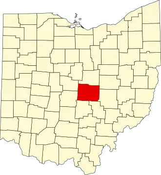 | |
| Villages | ||
| Townships | ||
| CDPs | ||
| Unincorporated communities | ||
| Ghost towns | ||
| Footnotes | ‡This populated place also has portions in an adjacent county or counties | |