Körner, Germany
Körner | |
|---|---|
_01.jpg) Körner seen from the north | |
 Coat of arms | |
Location of Körner within Unstrut-Hainich-Kreis district 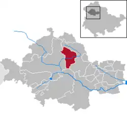 | |
 Körner  Körner | |
| Coordinates: 51°13′52″N 10°35′15″E / 51.23111°N 10.58750°E | |
| Country | Germany |
| State | Thuringia |
| District | Unstrut-Hainich-Kreis |
| Government | |
| • Mayor (2024–30) | Matthias Niebuhr[1] (Ind.) |
| Area | |
• Total | 30.64 km2 (11.83 sq mi) |
| Elevation | 208 m (682 ft) |
| Population (2024-12-31)[2] | |
• Total | 1,604 |
| • Density | 52/km2 (140/sq mi) |
| Time zone | UTC+01:00 (CET) |
| • Summer (DST) | UTC+02:00 (CEST) |
| Postal codes | 99998 |
| Dialling codes | 036025 |
| Vehicle registration | UH |
| Website | www.koerner-volkenroda.de |
Körner is a municipality in the Unstrut-Hainich-Kreis district of Thuringia, Germany.
History
Within the German Empire (1871-1945), Körner was part of the Duchy of Saxe-Coburg and Gotha.
Körner is the place with the highest postal code number in Germany - 99998.
References
- ^ Gewählte Bürgermeister - aktuelle Landesübersicht, Freistaat Thüringen. Retrieved 25 June 2024.
- ^ "Bevölkerung der Gemeinden vom Thüringer Landesamt für Statistik" (in German). Thüringer Landesamt für Statistik.
Towns and municipalities in Unstrut-Hainich-Kreis | ||
|---|---|---|
 | ||