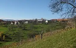
Kale, Žalec
Kale | |
|---|---|
 | |
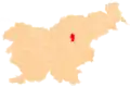
 Kale Location in Slovenia | |
| Coordinates: 46°18′11.3″N 15°7′42.22″E / 46.303139°N 15.1283944°E | |
| Country | |
| Traditional region | Styria |
| Statistical region | Savinja |
| Municipality | Žalec |
| Area | |
• Total | 2.68 km2 (1.03 sq mi) |
| Elevation | 448.4 m (1,471.1 ft) |
| Population (2002) | |
• Total | 168 |
| [1] | |
Kale (pronounced [ˈkaːlɛ]) is a village in the Municipality of Žalec in east-central Slovenia. It lies in the Ložnica Hills (Slovene: Ložniško gričevje) north of Šempeter v Savinjski Dolini. The area is part of the traditional region of Styria. The municipality is now included in the Savinja Statistical Region.[2]
A small chapel-shrine in the settlement dates to the late 19th century.[3]
References
- ^ Statistical Office of the Republic of Slovenia
- ^ Žalec municipal site
- ^ Slovenian Ministry of Culture register of national heritage reference number ešd 27578