Kalletal
Kalletal | |
|---|---|
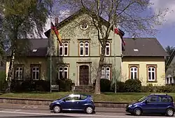 Town hall | |
 Coat of arms | |
Location of Kalletal within Lippe district 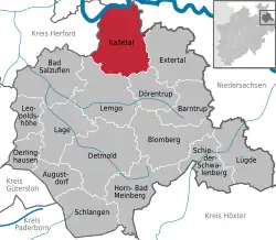 | |
 Kalletal  Kalletal | |
| Coordinates: 52°07′00″N 08°56′59″E / 52.11667°N 8.94972°E | |
| Country | Germany |
| State | North Rhine-Westphalia |
| Admin. region | Detmold |
| District | Lippe |
| Government | |
| • Mayor (2020–25) | Mario Hecker[1] (Ind.) |
| Area | |
• Total | 112.42 km2 (43.41 sq mi) |
| Elevation | 214 m (702 ft) |
| Population (2023-12-31)[2] | |
• Total | 13,330 |
| • Density | 120/km2 (310/sq mi) |
| Time zone | UTC+01:00 (CET) |
| • Summer (DST) | UTC+02:00 (CEST) |
| Postal codes | 32689 |
| Dialling codes | 05264 |
| Vehicle registration | LIP |
| Website | www.kalletal.de |
Kalletal (German pronunciation: [ˈkaləˌtaːl] ⓘ, lit. 'Kalle Valley') is a municipality in the Lippe district of North Rhine-Westphalia, Germany, with c. 13,500 inhabitants (2019).
Comprising villages (Ortschaften)
- Asendorf
- Bavenhausen
- Bentorf
- Brosen
- Erder
- Heidelbeck
- Henstorf
- Hohenhausen
- Kalldorf
- Langenholzhausen
- Lüdenhausen
- Osterhagen
- Stemmen
- Talle
- Tevenhausen
- Varenholz
- Westorf
References
- ^ Wahlergebnisse in NRW Kommunalwahlen 2020, Land Nordrhein-Westfalen, accessed 21 June 2021.
- ^ "Bevölkerung der Gemeinden Nordrhein-Westfalens am 31. Dezember 2023 – Fortschreibung des Bevölkerungsstandes auf Basis des Zensus vom 9. Mai 2011" (in German). Landesbetrieb Information und Technik NRW. Retrieved 2025-04-27.
External links
- Official website (in German)
Towns and municipalities in Lippe | ||
|---|---|---|
 | ||