Kallimedu
Kallimedu | |
|---|---|
Village | |
 Kallimedu Location in Tamil Nadu, India  Kallimedu Kallimedu (India) | |
| Coordinates: 10°29′30″N 79°50′23″E / 10.49167°N 79.83972°E | |
| Country | |
| State | Tamil Nadu |
| District | Nagapattinam |
| Taluk | Vedaranyam |
| Area | |
• Total | 11.68 km2 (4.51 sq mi) |
| Population (2011) | |
• Total | 5,341 |
| • Density | 460/km2 (1,200/sq mi) |
| Languages | |
| • Official | Tamil |
| Time zone | UTC+5:30 (IST) |
| Vehicle registration | TN-51 |
| Nearest city | Nagapattinam |
| Lok Sabha constituency | Nagapattinam |
Kallimedu is a village under the Talaignairu panchayat located near Vedaranyam in the Nagapattinam district, Tamil Nadu. As of the year 2011, it had a population of 5,341.[1]
Geography
Kallimedu is situated on the eastern shore of the Vedaranyam Canal, about 35 kilometres south of the district headquarter Nagapattinam. It has an average elevation of 2 metres above the sea level, and covers an area of 1167.7 hectares.[2][1]
Galleries
-
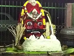 Pooja offerings for Sri Aravan
 -
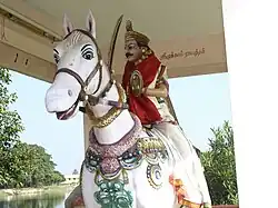 Sri Muthal Rawuther in Throwapathai amman Temple
References
- ^ a b Census of India 2011 Tamil Nadu District Census Handbook Nagapattinam (PDF). Directorate of Census Operations, Tamil Nadu. p. 160. Retrieved 23 October 2023.
- ^ "Kallimedu topographic map, elevation, terrain". Topographic maps. Retrieved 23 October 2023.