Kanakeravan
40°14′50″N 44°32′12″E / 40.24722°N 44.53667°E
Kanakeravan
Քանաքեռավան | |
|---|---|
 Kanakeravan | |
 Kanakeravan | |
| Coordinates: 40°14′50″N 44°32′12″E / 40.24722°N 44.53667°E | |
| Country | |
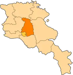
| Province | Kotayk |
| Elevation | 1,250 m (4,100 ft) |
| Population (2011) | |
• Total | 3,071[1] |
| Time zone | UTC+4 ( ) |
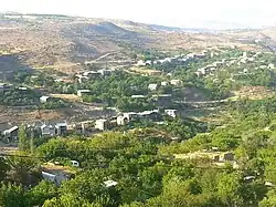
Kanakeravan (Armenian, Քանաքեռավան), a village in the Kotayk Province of Armenia, 42 km southwest of the province's center, on the high right bank of the Hrazdan river, blocking KERG.
See also
References
- ^ "Kotayk (Armenia): Towns and Villages in Municipalities". www.citypopulation.de. Retrieved 2024-11-08.
- Kanakeravan at GEOnet Names Server
- World Gazeteer: Armenia – World-Gazetteer.com
- Report of the results of the 2001 Armenian Census, Statistical Committee of Armenia