Kavelstorf
Kavelstorf | |
|---|---|
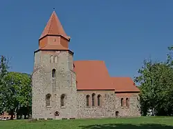 Medieval village church in Kavelstorf | |
Location of Kavelstorf within the former district of Bad Doberan 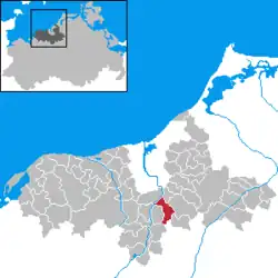 | |
 Kavelstorf  Kavelstorf | |
| Coordinates: 54°0′N 12°11′E / 54.000°N 12.183°E | |
| Country | Germany |
| State | Mecklenburg-Vorpommern |
| District | Rostock |
| Municipality | Dummerstorf |
| Area | |
• Total | 20.41 km2 (7.88 sq mi) |
| Elevation | 31 m (102 ft) |
| Population (2006-12-31) | |
• Total | 1,217 |
| • Density | 60/km2 (150/sq mi) |
| Time zone | UTC+01:00 (CET) |
| • Summer (DST) | UTC+02:00 (CEST) |
| Postal codes | 18196 |
| Dialling codes | 038208 |
| Vehicle registration | DBR |
Kavelstorf is a village and a former municipality in the district of Rostock, in Mecklenburg-Vorpommern, Germany. Since 7 June 2009, it has been part of the Dummerstorf municipality. Before this, it was part of the Warnow-Ost Amt.