Keeler Farm, New Mexico
Keeler Farm, New Mexico | |
|---|---|
 Keeler Farm  Keeler Farm | |
| Coordinates: 32°18′42″N 107°44′55″W / 32.31167°N 107.74861°W | |
| Country | United States |
| State | New Mexico |
| County | Luna |
| Area | |
• Total | 11.39 sq mi (29.50 km2) |
| • Land | 11.39 sq mi (29.50 km2) |
| • Water | 0.00 sq mi (0.00 km2) |
| Elevation | 4,400 ft (1,300 m) |
| Population | |
• Total | 1,146 |
| • Density | 100.61/sq mi (38.85/km2) |
| Time zone | UTC-7 (Mountain (MST)) |
| • Summer (DST) | UTC-6 (MDT) |
| Area code | 575 |
| GNIS feature ID | 2584117[2] |
Keeler Farm is a census-designated place in Luna County, New Mexico, United States. Its population was 1,305 as of the 2010 census.[4]
Like other areas in Luna County, the community is in the Deming Public Schools school district.[5]
Demographics
| Census | Pop. | Note | %± |
|---|---|---|---|
| 2020 | 1,146 | — | |
| U.S. Decennial Census[6][3] | |||
References
- ^ "ArcGIS REST Services Directory". United States Census Bureau. Retrieved October 12, 2022.
- ^ a b U.S. Geological Survey Geographic Names Information System: Keeler Farm, New Mexico
- ^ a b "Census Population API". United States Census Bureau. Retrieved October 12, 2022.
- ^ "U.S. Census website". United States Census Bureau. Retrieved May 14, 2011.
- ^ "2020 CENSUS - SCHOOL DISTRICT REFERENCE MAP: Luna County, NM" (PDF). U.S. Census Bureau. Retrieved June 28, 2022.
- ^ "Census of Population and Housing". Census.gov. Retrieved June 4, 2016.
Municipalities and communities of Luna County, New Mexico, United States | ||
|---|---|---|
| City | 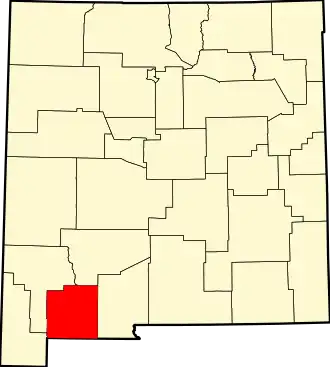 | |
| Village | ||
| CDPs | ||
| Ghost towns | ||
| Indian reservation | ||