Kerki
Kerki
Atamyrat (1999-2017) Zamm (in antiquity) | |
|---|---|
 Kerki airport | |
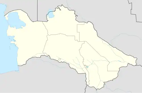 Kerki Location in Turkmenistan | |
| Coordinates: 37°51′11″N 65°14′13″E / 37.85306°N 65.23694°E | |
| Country | |
| Province | Lebap Province |
| District | Kerki District |
| Population (2011) | |
• Total | 96,720 |
| Time zone | UTC+5 |
Kerki is a city in and capital of Kerki District, Lebap Province, Turkmenistan. It was formerly known as Zamm[1] and, between 1999 and 2017, as Atamyrat.
Geography
It is situated on a plain on the left bank of the Amu Darya river. Nearby towns and villages include Mukry (3.3 nm), Amydarýa (2.1 nm), Surhy (3.1 nm) and Kerkichi (2.2 nm).[2]
Climate
| Climate data for Kerki (1991–2020) | |||||||||||||
|---|---|---|---|---|---|---|---|---|---|---|---|---|---|
| Month | Jan | Feb | Mar | Apr | May | Jun | Jul | Aug | Sep | Oct | Nov | Dec | Year |
| Record high °C (°F) | 24.4 (75.9) |
29.9 (85.8) |
35.4 (95.7) |
39.0 (102.2) |
42.8 (109.0) |
44.4 (111.9) |
46.0 (114.8) |
45.5 (113.9) |
41.1 (106.0) |
36.7 (98.1) |
32.9 (91.2) |
27.4 (81.3) |
46.0 (114.8) |
| Mean maximum °C (°F) | 19.5 (67.1) |
23.0 (73.4) |
29.5 (85.1) |
34.9 (94.8) |
39.1 (102.4) |
42.2 (108.0) |
43.7 (110.7) |
42.1 (107.8) |
38.5 (101.3) |
32.7 (90.9) |
27.7 (81.9) |
21.1 (70.0) |
32.8 (91.0) |
| Daily mean °C (°F) | 4.7 (40.5) |
7.1 (44.8) |
12.7 (54.9) |
19.1 (66.4) |
25.1 (77.2) |
29.7 (85.5) |
31.0 (87.8) |
28.8 (83.8) |
23.2 (73.8) |
16.6 (61.9) |
10.2 (50.4) |
5.6 (42.1) |
17.8 (64.0) |
| Mean minimum °C (°F) | −6.8 (19.8) |
−5.8 (21.6) |
−0.9 (30.4) |
4.7 (40.5) |
11.2 (52.2) |
16.3 (61.3) |
18.0 (64.4) |
14.7 (58.5) |
8.9 (48.0) |
2.3 (36.1) |
−2.9 (26.8) |
−6.1 (21.0) |
4.5 (40.1) |
| Record low °C (°F) | −22.8 (−9.0) |
−19.0 (−2.2) |
−6.9 (19.6) |
−0.3 (31.5) |
6.2 (43.2) |
12.6 (54.7) |
16.4 (61.5) |
11.2 (52.2) |
4.8 (40.6) |
−3.6 (25.5) |
−9.0 (15.8) |
−20.9 (−5.6) |
−22.8 (−9.0) |
| Average precipitation mm (inches) | 25.7 (1.01) |
36.9 (1.45) |
37.0 (1.46) |
28.2 (1.11) |
10.0 (0.39) |
1.7 (0.07) |
0.9 (0.04) |
0.0 (0.0) |
0.2 (0.01) |
3.5 (0.14) |
17.6 (0.69) |
23.3 (0.92) |
185.0 (7.28) |
| Average precipitation days (≥ 1.0 mm) | 16.1 | 18.4 | 17.5 | 13.9 | 6.7 | 1.1 | 0.3 | 0.0 | 0.4 | 2.4 | 12.0 | 12.2 | 100.9 |
| Source: NOAA[3] | |||||||||||||
Etymology
According to Atanyyazow, the name Kerki is most likely of Persian origin, from ker ("fortress") and kuh ("mountain"), meaning "fortress on a mountain".[4] However, Muqaddasī and de Goeje assert it is a Turkified pronunciation of the Persian name Karkuh (کرکوه), meaning "deaf mountain".[5] The ancient name, Zamm, is of obscure origin.
On 29 December 1999, by Parliamentary Resolution HM-60, the city and district of Kerki were renamed Atamyrat in honor of Atamyrat Nyýazow, father of Saparmurat Niyazov, who had worked in Kerki as a teacher before being killed in World War II. On 25 November 2017, by Parliamentary Resolution No. 679-V, Atamyrat was changed back to Kerki for both the city and the district.[6]
Architecture
The urban core consists of numerous one-story brick structures dating back to the period of the Russian Empire..[7]
Transportation
Air
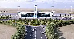
The town is served by the new Kerki Airport, which replaced a defunct municipal airport in 2021.[8]
Road
Kerki lies on the P-36 and P-39 highways, which both lead northwest to Turkmenabat, one on each side of the Amu Darya. Nearby junctions connect to the P-89, which leads north to the border with Uzbekistan at Tallymerjen, and the P-37, which leads southeast to the border with Uzbekistan at Kelif. In the opposite direction the P-36 also continues south to a junction with the Kerki-Ymamnazar ýoly, which in turn leads to the border with Afghanistan at Ymamnazar.[9] In February 2013, a road bridge connecting the city with Kerkichi was commissioned;[10] it replaced an old pontoon bridge.[7]
Rail
In 1999, the rail line from Türkmenabat to Kerki was finished, linking Kerki to the Turkmen railway network without having to detour into neighbouring Uzbekistan.[11] In late 2016, a railway line was built south to Ymamnazar on the border with Afghanistan and further to Aqina, turning Kerki into a railway hub.[12]
Sights
Astana Baba Mausoleum is managed by the Kerki city museum, and consists of a minaret and tomb built in the 11th century. Allamberdar Mausoleum (ru) is also part of the Kerki city museum. This 11th-century building represents Seljuk architecture of northern Khorasan.
See also
References
- ^ Bosworth, C. E. (1989). "ĀMOL (ĀMŪYA)". Archived copy. Encyclopaedia Iranica, Vol. I, Fasc. 9. pp. 982–983. Archived from the original on 2017-12-29. Retrieved 2016-02-08.
{{cite encyclopedia}}: CS1 maint: archived copy as title (link) - ^ Falling rain gazetteer
- ^ "World Meteorological Organization Climate Normals for 1991-2020". National Oceanic and Atmospheric Administration. Retrieved February 6, 2024.
- ^ Atanyýazow, Soltanşa (1980). Түркменистаның Географик Атларының Дүшүндиришли Сөзлүги [Explanatory Dictionary of Geographic Names in Turkmenistan]. Ashgabat: Ылым. p. 182.
- ^ Muqaddasī, Muḥammad ibn Aḥmad, and M. J. de Goeje. 1967. Kitāb Aḥsan al-taqāsīm fī maʻrifat al-aqālīm. Bibliotheca geographorum Arabicorum, pars 3. Laydin: Maṭbaʻ Brīl.
- ^ "Внесены изменения в административно-территориальное деление Лебапского велаята" [Changes to the administrative-territorial divisions in Lebap velayat] (in Russian). Türkmenistan Bu Gün. 2017-11-27. Archived from the original on 2018-07-30. Retrieved 2018-01-05.
- ^ a b Brummell, Paul (2005). Turkmenistan. Bradt Travel Guides. p. 197. ISBN 978-1-84162-144-9.
- ^ "Kerki Airport awarded ICAO Code and International Certificate of Conformity". "Turkmenistan: Golden Age". 24 June 2021.
- ^ OpenStreetMap
- ^ Президенты Украины и Туркмении открыли мост через Амударью и заложили новый аэропорт
- ^ Grantham, Andrew (15 July 2008). "Atamyrat to Afghanistan railway plan". Retrieved 17 January 2017.
- ^ Salehai, Zarghona (28 November 2016). "Afghan-Turkmenistan railroad inaugurated". Pajhwok Afghan News. Retrieved 17 January 2017.