Kessel, Limburg
Kessel | |
|---|---|
Small city and former municipality | |
 | |
 Flag _wapen.svg.png) Coat of arms | |
 Kessel Location in the Netherlands 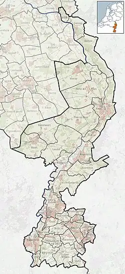 Kessel Location in the province of Limburg in the Netherlands | |
| Coordinates: 51°17′N 6°03′E / 51.283°N 6.050°E | |
| Country | Netherlands |
| Province | Limburg |
| Municipality | Peel en Maas |
| Area | |
• Total | 10.44 km2 (4.03 sq mi) |
| Elevation | 21 m (69 ft) |
| Population (2021)[1] | |
• Total | 3,190 |
| • Density | 310/km2 (790/sq mi) |
| Time zone | UTC+1 (CET) |
| • Summer (DST) | UTC+2 (CEST) |
| Postal code | 5995[1] |
| Dialing code | 077 |
| Website | www.kessellimburg.nl/ |
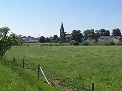
Kessel (Dutch pronunciation: [ˈkɛsəl] ⓘ) is a former municipality and a city in the southeastern province of Limburg, in the Netherlands. It is a small historic municipality with 4,246 residents. It merged with neighbouring municipalities in the new municipality of Peel en Maas (as of 1 January 2010). To the west are the Heldense Bossen (Helden Forest) and to the east is the Meuse river.
It has a small historic city center with a castle and a historic marketplace. To the south is the Kessel-Eik neighbourhood with the Eikelenpeel and Musschenberg.
History
The d'Ewes baronets of Stowlangtoft, England are descended from Gerard D'Ewes, Lord of Kessel, at that time part of Duchy of Gelderland.[3]
Gallery
-
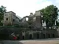 Ruins of Keverberg Castle
 -
 Ferry across the Maas
 -
 Estate Oeverberg
 -
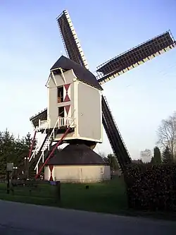 Windmill St Anthoniusmolen
References
- ^ a b c "Kerncijfers wijken en buurten 2021". Central Bureau of Statistics. Retrieved 25 April 2022.
two entries
- ^ "Postcodetool for 5995AA". Actueel Hoogtebestand Nederland (in Dutch). Het Waterschapshuis. Archived from the original on 21 September 2013. Retrieved 25 April 2022.
- ^ Sir Richard Gipps On the Ancient Families of Suffolk, Proceedings of the Suffolk Institute of Archæology and Natural History, 1874, p.155 [1]
External links
 Media related to Kessel, Limburg at Wikimedia Commons
- Official website