Kewadin, Michigan
Kewadin, Michigan | |
|---|---|
| Etymology: giiwedin (Ojibwe) | |
 Kewadin  Kewadin | |
| Coordinates: 44°55′03″N 85°22′23″W / 44.91750°N 85.37306°W | |
| Country | |
| State | |
| County | Antrim |
| Township | Milton |
| Settled | 1856 |
| Elevation | 600 ft (183 m) |
| Time zone | UTC-5 (Eastern (EST)) |
| • Summer (DST) | UTC-4 (EDT) |
| ZIP code(s) | 49648 49629 (Elk Rapids) |
| Area code | 231 |
| GNIS feature ID | 629640[1] |
Kewadin (/kəˈweɪˈdən/ kə-WAY-dən) is an unincorporated community in the U.S. state of Michigan. The community is located in Milton Township, Antrim County, and is located on the northern shore of Elk Lake, roughly 2 miles (3.2 km) northeast of the village of Elk Rapids. As an unincorporated community, Kewadin has no legally defined boundaries or population statistics of its own. However, a post office operates out of the community, with the ZIP Code 49648.[2]
History
The Kewadin area was occupied by indigenous peoples until 1876, when a European settlement was established, known as Indian Town. On June 4, 1883, a post office opened in the community, and it was renamed to Kewadin, after the Ojibwe word giiwedin, meaning 'north'.[3][4][5]
References
- ^ a b "Kewadin". Geographic Names Information System. United States Geological Survey, United States Department of the Interior.
- ^ "PO Locator | USPS". tools.usps.com. Retrieved 12 December 2023.
- ^ Romig, Walter (1986). Michigan Place Names: The History of the Founding and the Naming of More Than Five Thousand Past and Present Michigan Communities. Detroit: Wayne State University Press. p. 302. ISBN 0-8143-1838-X.
- ^ "giiwedin (ni) | | the Ojibwe People's Dictionary". ojibwe.lib.umn.edu. Retrieved 12 December 2023.
- ^ "Land of Anishinabek Historical Marker". www.hmdb.org. Retrieved 12 December 2023.
Municipalities and communities of Antrim County, Michigan, United States | ||
|---|---|---|
| Villages | 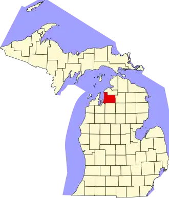 | |
| Civil townships | ||
| CDPs | ||
| Other communities | ||
| Ghost towns | ||
| Indian reservation | ||
| Footnotes | ‡This populated place also has portions in an adjacent county or counties | |