Kickapoo Site 2, Kansas
Kickapoo Site 2, Kansas | |
|---|---|
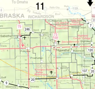 KDOT map of Brown County (legend) | |
 Kickapoo Site 2  Kickapoo Site 2 | |
| Coordinates: 39°42′1″N 95°39′10″W / 39.70028°N 95.65278°W[1] | |
| Country | United States |
| State | Kansas |
| County | Brown |
| Area | |
• Total | 0.8 sq mi (2.2 km2) |
| • Land | 0.8 sq mi (2.2 km2) |
| • Water | 0.0 sq mi (0.0 km2) |
| Elevation | 1,096 ft (334 m) |
| Population | |
• Total | 27 |
| • Density | 32/sq mi (12/km2) |
| Time zone | UTC-6 (CST) |
| • Summer (DST) | UTC-5 (CDT) |
| Area code | 785 |
| FIPS code | 20-36736[1] |
| GNIS ID | 2583501[1] |
Kickapoo Site 2 is a census-designated place (CDP) in Brown County, Kansas, United States, on the Kickapoo Indian Reservation.[1] As of the 2020 census, the population was 27.[2]
Geography
Kickapoo Site 2 is located in southwestern Brown County near the center of the Kickapoo Reservation. According to the United States Census Bureau, the CDP has a total area of 0.85 square miles (2.2 km2), all land.[3]
Demographics
| Census | Pop. | Note | %± |
|---|---|---|---|
| 2010 | 34 | — | |
| 2020 | 27 | −20.6% | |
| U.S. Decennial Census | |||
The 2020 United States census counted 27 people, 9 households, and 6 families in Kickapoo Site 2.[4][5] The population density was 31.6 per square mile (12.2/km2). There were 9 housing units at an average density of 10.5 per square mile (4.1/km2).[5][6] The racial makeup was 0.0% (0) white or European American (0.0% non-Hispanic white), 0.0% (0) black or African-American, 92.59% (25) Native American or Alaska Native, 0.0% (0) Asian, 0.0% (0) Pacific Islander or Native Hawaiian, 0.0% (0) from other races, and 7.41% (2) from two or more races.[7] Hispanic or Latino of any race was 0.0% (0) of the population.[8]
Of the 9 households, 66.7% had children under the age of 18; 0.0% were married couples living together; 66.7% had a female householder with no spouse or partner present. 11.1% of households consisted of individuals and 0.0% had someone living alone who was 65 years of age or older.[5] The average household size was 4.4 and the average family size was 5.0.[9]
18.5% of the population was under the age of 18, 18.5% from 18 to 24, 22.2% from 25 to 44, 22.2% from 45 to 64, and 18.5% who were 65 years of age or older. The median age was 31.5 years. For every 100 females, there were 1250.0 males.[5] For every 100 females ages 18 and older, there were 1000.0 males.[5]
References
- ^ a b c d e "Kickapoo Site 2, Kansas", Geographic Names Information System, United States Geological Survey, United States Department of the Interior
- ^ a b "Profile of Kickapoo Site 2, Kansas (CDP) in 2020". United States Census Bureau. Archived from the original on July 10, 2022. Retrieved July 10, 2022.
- ^ "Geographic Identifiers: 2010 Demographic Profile Data (G001): Kickapoo Site 2 CDP, Kansas". U.S. Census Bureau, American Factfinder. Archived from the original on February 12, 2020. Retrieved November 18, 2013.
- ^ "US Census Bureau, Table P16: HOUSEHOLD TYPE". data.census.gov. Retrieved January 16, 2024.
- ^ a b c d e "US Census Bureau, Table DP1: PROFILE OF GENERAL POPULATION AND HOUSING CHARACTERISTICS". data.census.gov. Retrieved January 16, 2024.
- ^ "Gazetteer Files". Census.gov. United States Census Bureau. Retrieved December 30, 2023.
- ^ "US Census Bureau, Table P1: RACE". data.census.gov. Retrieved January 16, 2024.
- ^ "US Census Bureau, Table P2: HISPANIC OR LATINO, AND NOT HISPANIC OR LATINO BY RACE". data.census.gov. Retrieved January 16, 2024.
- ^ "US Census Bureau, Table S1101: HOUSEHOLDS AND FAMILIES". data.census.gov. Retrieved January 16, 2024.
Further reading
External links
- Kansas Kickapoo Tribe official website
- Brown County maps: Current, Historic Archived February 24, 2024, at the Wayback Machine, KDOT
Municipalities and communities of Brown County, Kansas, United States | ||
|---|---|---|
| Cities |  | |
| CDPs | ||
| Unincorporated communities | ||
| Indian reservations | ||
| Townships | ||
| Footnotes | ‡This community also has portions in an adjacent county or counties. | |