Knoxlyn, Pennsylvania
Knoxlyn, Pennsylvania | |
|---|---|
 Knoxlyn  Knoxlyn | |
| Coordinates: 39°49′51″N 77°19′01″W / 39.83083°N 77.31694°W | |
| Country | United States |
| State | Pennsylvania |
| County | Adams |
| Elevation | 541 ft (165 m) |
| Time zone | UTC-5 (Eastern (EST)) |
| • Summer (DST) | UTC-4 (EDT) |
| Area codes | 717 & 223 |
| GNIS feature ID | 1203958[1] |
Knoxlyn is an unincorporated community situated in Highland Township in Adams County, Pennsylvania, United States.[1] It is located 8 kilometers (5.0 mi) west of Gettysburg between U.S. Route 30 and Pennsylvania Route 116.[2]
References
- ^ a b "Knoxlyn". Geographic Names Information System. United States Geological Survey, United States Department of the Interior.
- ^ General Highway Map: Adams County, Pennsylvania (PDF) (Map). Pennsylvania Department of Transportation. 2018. Archived from the original (PDF) on October 16, 2015. Retrieved March 11, 2019.
Municipalities and communities of Adams County, Pennsylvania, United States | ||
|---|---|---|
| Boroughs | 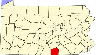 | |
| Townships | ||
| CDPs | ||
| Unincorporated communities | ||
| Ghost town | ||