Kodikuthimala
| Kodikuthimala | |
|---|---|
 | |
| Highest point | |
| Elevation | 540 m (1,770 ft) |
| Geography | |
| Location | Perinthalmanna taluk, Malappuram district, Kerala, India |
| Parent range | Amminikkadan mountain |
| Geology | |
| Mountain type | Free-standing mountain |
| Climbing | |
| Easiest route | From Perinthalmanna, via Amminikkad |
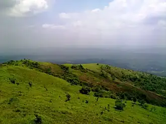
Kodikuthimala, also known as the Ooty of Malappuram [1] and Mini Ooty [2] is a hill station in Vettathur and Thazhekode villages, in Kerala, India. At a height of 540 metres (1,770 ft) above sea level, it is the highest peak in Amminikkadan hills.[3]
The British hoisted their flag on this hilltop during a survey, thus getting the name Kodikuthimala. Around 70 acres of land in this area is earmarked by the Tourism Department for various projects. Kodikuthimala, at an altitude of 1,713-ft above sea level, has a watch tower that is visited by tourists because of the vantage point it offers. It is located 9 km from Perintalmanna, 32 km from Malappuram, 66 km from Palakkad and 82 km from Calicut.[1]
References
- ^ a b "The Ooty Of Malappuram-Kodikuthimala". Deccan Chronicle. 18 April 2014. Retrieved 8 August 2018.
- ^ https://www.keralatourism.org/photo-gallery/arimba-hills-malappuram/2591.
- ^ "Kodikuthimala | Ooty of Malappuram | Tourist Places in Malappuram". Kerala Tourism. Retrieved 31 May 2022.
External links
Wikimedia Commons has media related to Kodikuthimala.