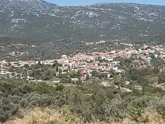
Konistres
Konistres
Κονίστρες | |
|---|---|
 | |
 Konistres Location within the regional unit 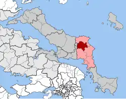 | |
| Coordinates: 38°34′N 24°03′E / 38.567°N 24.050°E | |
| Country | Greece |
| Administrative region | Central Greece |
| Regional unit | Euboea |
| Municipality | Kymi-Aliveri |
| Area | |
| • Municipal unit | 127.6 km2 (49.3 sq mi) |
| Population (2021)[1] | |
| • Municipal unit | 2,789 |
| • Municipal unit density | 22/km2 (57/sq mi) |
| • Community | 722 |
| Time zone | UTC+2 (EET) |
| • Summer (DST) | UTC+3 (EEST) |
| Vehicle registration | ΧΑ |
Konistres (Greek: Κονίστρες) is a village and a former municipality in Euboea, Greece. Since a local government reform in 2011, it has been part of the municipality of Kymi-Aliveri, of which it is a municipal unit.[2] The municipal unit has an area of 127.559 km2.[3] Population 2,789 (2021). Konistres emanates from the ancient word "Konistra". Konistra means palaistra (in Greek), which is a wrestling pitch.
References
- ^ "Αποτελέσματα Απογραφής Πληθυσμού - Κατοικιών 2021, Μόνιμος Πληθυσμός κατά οικισμό" [Results of the 2021 Population - Housing Census, Permanent population by settlement] (in Greek). Hellenic Statistical Authority. 29 March 2024.
- ^ "ΦΕΚ B 1292/2010, Kallikratis reform municipalities" (in Greek). Government Gazette.
- ^ "Population & housing census 2001 (incl. area and average elevation)" (PDF) (in Greek). National Statistical Service of Greece. Archived from the original (PDF) on 2015-09-21.