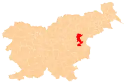
Kostrivnica
Kostrivnica | |
|---|---|
 Kostrivnica Location in Slovenia | |
| Coordinates: 46°9′14.58″N 15°22′22.78″E / 46.1540500°N 15.3729944°E | |
| Country | |
| Traditional region | Styria |
| Statistical region | Savinja |
| Municipality | Šentjur |
| Area | |
• Total | 3.78 km2 (1.46 sq mi) |
| Elevation | 335 m (1,099 ft) |
| Population | |
• Total | 196 |
| • Density | 52/km2 (130/sq mi) |
| [3] | |
Kostrivnica (pronounced [kɔˈstɾiːu̯nitsa]) is a dispersed settlement in the Municipality of Šentjur, in eastern Slovenia. It lies in the northern part of the Sava Hills (Slovene: Posavsko hribovje) north of Planina. The settlement, and the entire municipality, are included in the Savinja Statistical Region, which is in the Slovenian portion of the historical Duchy of Styria.[4]
References
- ^ Razpotnik, Barica (2020-06-08). "On 1 January 2020, 2,095,861 residents of Slovenia lived in 5,978 settlements; 57 settlements were unpopulated" (Press release). Ljubljana: Statistical Office of the Republic of Slovenia. Retrieved 2021-01-09.
final data (XLS attachment)
- ^ Prebivalci po spolu, občine in naselja, Slovenija, 1. januar 2020 [Population by sex, municipalities and resorts, Slovenia, 1 January 2020]. Statistical Office of the Republic of Slovenia (XLS) (in Slovenian). Ljubljana. 2020-06-08. Retrieved 2021-01-09.
(note: for Šentjur, the municipality is at code 120, followed immediately by its settlements at codes 120001–120121)
- ^ Statistical Office of the Republic of Slovenia
- ^ Šentjur municipal site Archived 2011-01-15 at the Wayback Machine