Kouloukonas
Kouloukonas
Κουλούκωνας | |
|---|---|
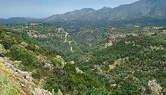 Landscape around Agios Ioannis | |
 Kouloukonas Location within the regional unit 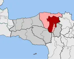 | |
| Coordinates: 35°19′N 24°48′E / 35.317°N 24.800°E | |
| Country | Greece |
| Administrative region | Crete |
| Regional unit | Rethymno |
| Municipality | Mylopotamos |
| Area | |
| • Municipal unit | 148.2 km2 (57.2 sq mi) |
| Population (2021)[1] | |
| • Municipal unit | 4,098 |
| • Municipal unit density | 28/km2 (72/sq mi) |
| Time zone | UTC+2 (EET) |
| • Summer (DST) | UTC+3 (EEST) |
| Vehicle registration | ΡΕ |
Kouloukonas (Greek: Κουλούκωνας) is a former municipality in the Rethymno regional unit, Crete, Greece. Since the 2011 local government reform it is part of the municipality Mylopotamos, of which it is a municipal unit.[2] The municipal unit has an area of 148.187 km2 (57.215 sq mi).[3] Population 4,098 (2021). The seat of the municipality was in Garazo.
References
- ^ "Αποτελέσματα Απογραφής Πληθυσμού - Κατοικιών 2021, Μόνιμος Πληθυσμός κατά οικισμό" [Results of the 2021 Population - Housing Census, Permanent population by settlement] (in Greek). Hellenic Statistical Authority. 29 March 2024.
- ^ "ΦΕΚ B 1292/2010, Kallikratis reform municipalities" (in Greek). Government Gazette.
- ^ "Population & housing census 2001 (incl. area and average elevation)" (PDF) (in Greek). National Statistical Service of Greece. Archived from the original (PDF) on 2015-09-21., including former municipal department Axos from Anogeia
Wikimedia Commons has media related to Kouloukonas.