Krahulčí
Krahulčí | |
|---|---|
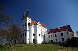 Church of Saint John of Nepomuk | |
 Flag  Coat of arms | |
 Krahulčí Location in the Czech Republic | |
| Coordinates: 49°10′55″N 15°24′53″E / 49.18194°N 15.41472°E | |
| Country | |
| Region | Vysočina |
| District | Jihlava |
| First mentioned | 1366 |
| Area | |
• Total | 3.64 km2 (1.41 sq mi) |
| Elevation | 531 m (1,742 ft) |
| Population (2025-01-01)[1] | |
• Total | 633 |
| • Density | 170/km2 (450/sq mi) |
| Time zone | UTC+1 (CET) |
| • Summer (DST) | UTC+2 (CEST) |
| Postal code | 588 56 |
| Website | www |
Krahulčí (Czech pronunciation: [ˈkraɦultʃiː]) is a municipality and village in Jihlava District in the Vysočina Region of the Czech Republic. It has about 600 inhabitants.
Krahulčí lies approximately 28 kilometres (17 mi) south-west of Jihlava and 124 km (77 mi) south-east of Prague.
Demographics
| Year | Pop. | ±% |
|---|---|---|
| 1869 | 175 | — |
| 1880 | 212 | +21.1% |
| 1890 | 246 | +16.0% |
| 1900 | 224 | −8.9% |
| 1910 | 225 | +0.4% |
| 1921 | 263 | +16.9% |
| 1930 | 313 | +19.0% |
| 1950 | 376 | +20.1% |
| 1961 | 380 | +1.1% |
| 1970 | 386 | +1.6% |
| 1980 | 471 | +22.0% |
| 1991 | 513 | +8.9% |
| 2001 | 570 | +11.1% |
| 2011 | 652 | +14.4% |
| 2021 | 612 | −6.1% |
| Source: Censuses[2][3] | ||
References
- ^ "Population of Municipalities – 1 January 2025". Czech Statistical Office. 2025-05-16.
- ^ "Historický lexikon obcí České republiky 1869–2011" (in Czech). Czech Statistical Office. 2015-12-21.
- ^ "Population Census 2021: Population by sex". Public Database. Czech Statistical Office. 2021-03-27.
External links
Wikimedia Commons has media related to Krahulčí.