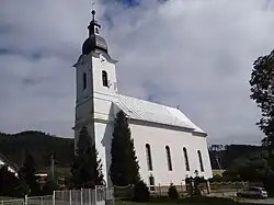
Kravany, Poprad District
Kravany | |
|---|---|
 | |
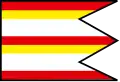 Flag 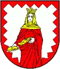 Coat of arms | |
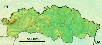 Kravany Location of Kravany in the Prešov Region  Kravany Location of Kravany in Slovakia | |
| Coordinates: 49°00′N 20°12′E / 49.00°N 20.20°E | |
| Country | |
| Region | |
| District | Poprad District |
| First mentioned | 1317 |
| Area | |
• Total | 24.34 km2 (9.40 sq mi) |
| Elevation | 730 m (2,400 ft) |
| Population (2021)[3] | |
• Total | 890 |
| Time zone | UTC+1 (CET) |
| • Summer (DST) | UTC+2 (CEST) |
| Postal code | 591 8[2] |
| Area code | +421 52[2] |
| Car plate | PP |
| Website | www |
Kravany (Hungarian: Erzsébetháza) is a village and municipality in the Poprad District in the Prešov Region of eastern Slovakia.[4]
References
- ^ "Hustota obyvateľstva - obce [om7014rr_ukaz: Rozloha (Štvorcový meter)]". www.statistics.sk (in Slovak). Statistical Office of the Slovak Republic. 2022-03-31. Retrieved 2022-03-31.
- ^ a b c "Základná charakteristika". www.statistics.sk (in Slovak). Statistical Office of the Slovak Republic. 2015-04-17. Retrieved 2022-03-31.
- ^ "Počet obyvateľov podľa pohlavia - obce (ročne)". www.statistics.sk (in Slovak). Statistical Office of the Slovak Republic. 2022-03-31. Retrieved 2022-03-31.
- ^ "Statistical Office of the Slovak Republic" (PDF). Výsledky SODB 2011. Štatistický úrad SR. Archived from the original (PDF) on October 12, 2013. Retrieved 12 August 2012.
External links
Municipalities of Poprad District | ||
|---|---|---|