Kyeintali Subtownship
Kyeintali Subtownship
ကျိန္တလီမြို့နယ်ခွဲ | |
|---|---|
Subtownship | |
| Coordinates: 18°01′N 94°32′E / 18.01°N 94.54°E | |
| Country | |
| State | Rakhine State |
| District | Thandwe District |
| Population | 23,581[1] |
| Time zone | UTC+6:30 (MMT) |
| Website | www.kyeintali.com |
Kyeintali Subtownship is divided from Gwa Township, Rakhine State. Government offices of Kyeintali Subtownship are located in Kyeintali[2]
References
- ^ Ministry of Immigration, Labor and Population (2014-03-29). "Rakhine State, Thandwe District, Kyeintali Sub-Township Report" (PDF). Myanmar Information Management Unit (in Burmese). Retrieved 22 December 2024.
- ^ "Google Maps". Google Maps. Retrieved 2016-07-10.
Capital: Sittwe | ||
| Ann District |  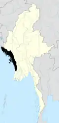 | |
| Kyaukpyu District | ||
| Maungdaw District |
| |
| Sittwe District | ||
| Taungup District | ||
| Thandwe District | ||
| Mrauk-U District | ||
| Main cities and towns | ||