Laab im Walde
Laab im Walde
Laab im Woid | |
|---|---|
 | |
 Coat of arms | |
 Laab im Walde Location within Austria | |
| Coordinates: 48°9′N 16°10′E / 48.150°N 16.167°E | |
| Country | Austria |
| State | Lower Austria |
| District | Mödling |
| Government | |
| • Mayor | Dr. Peter Klar |
| Area | |
• Total | 7.15 km2 (2.76 sq mi) |
| Elevation | 316 m (1,037 ft) |
| Population (2018-01-01)[2] | |
• Total | 1,137 |
| • Density | 160/km2 (410/sq mi) |
| Time zone | UTC+1 (CET) |
| • Summer (DST) | UTC+2 (CEST) |
| Postal code | 2381 |
| Area code | 02239 |
| Website | laab.gv.at |
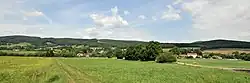
Laab im Walde (Central Bavarian: Laab im Woid) is a town in the district of Mödling in the Austrian state of Lower Austria.
Population
| Year | Pop. | ±% |
|---|---|---|
| 1971 | 624 | — |
| 1981 | 615 | −1.4% |
| 1991 | 910 | +48.0% |
| 2001 | 1,144 | +25.7% |
| 2011 | 1,145 | +0.1% |
References
- ^ "Dauersiedlungsraum der Gemeinden Politischen Bezirke und Bundesländer - Gebietsstand 1.1.2018". Statistics Austria. Retrieved 10 March 2019.
- ^ "Einwohnerzahl 1.1.2018 nach Gemeinden mit Status, Gebietsstand 1.1.2018". Statistics Austria. Retrieved 9 March 2019.