Lac-Bazinet
Lac-Bazinet | |
|---|---|
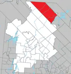 Location within Antoine-Labelle RCM. | |
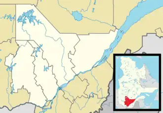 Lac-Bazinet Location in central Quebec. | |
| Coordinates: 47°27′N 74°46′W / 47.450°N 74.767°W[1] | |
| Country | |
| Province | |
| Region | Laurentides |
| RCM | Antoine-Labelle |
| Constituted | January 1, 1986 |
| Government | |
| • Federal riding | Laurentides—Labelle |
| • Prov. riding | Labelle |
| Area | |
• Total | 1,685.50 km2 (650.78 sq mi) |
| • Land | 1,549.05 km2 (598.09 sq mi) |
| Population (2011)[3] | |
• Total | 0 |
| • Density | 0.0/km2 (0/sq mi) |
| • Pop 2006-2011 | |
| • Dwellings | 1 |
| Time zone | UTC−5 (EST) |
| • Summer (DST) | UTC−4 (EDT) |
| Highways | No major routes |
Lac-Bazinet is an unorganized territory in the Laurentides region of Quebec, Canada, and one of the two most northerly of eleven unorganized areas in the Antoine-Labelle Regional County Municipality.
See also
References
- ^ "Banque de noms de lieux du Québec: Reference number 149699". toponymie.gouv.qc.ca (in French). Commission de toponymie du Québec.
- ^ a b "Répertoire des municipalités: Geographic code 79910". www.mamh.gouv.qc.ca (in French). Ministère des Affaires municipales et de l'Habitation.
- ^ a b Statistics Canada 2011 Census - Lac-Bazinet, Quebec profile
Adjacent Municipal Subdivisions | |
|---|---|
| Cities/towns | |
|---|---|
| Municipalities | |
| Villages | |
| Unorganized territories | |
| |