Lac-Boulé
Lac-Boulé | |
|---|---|
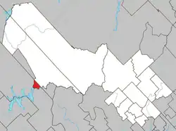 Location within Mékinac RCM. | |
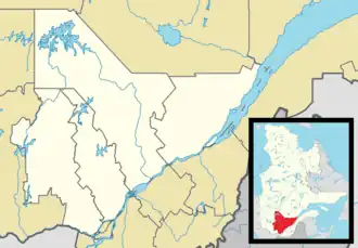 Lac-Boulé Location in central Quebec. | |
| Coordinates: 46°53′N 73°37′W / 46.883°N 73.617°W[1] | |
| Country | |
| Province | |
| Region | Mauricie |
| RCM | Mékinac |
| Constituted | March 13, 1986 |
| Government | |
| • Federal riding | Saint-Maurice—Champlain |
| • Prov. riding | Laviolette |
| Area | |
• Total | 24.40 km2 (9.42 sq mi) |
| • Land | 22.96 km2 (8.86 sq mi) |
| Population (2011)[3] | |
• Total | 0 |
| • Density | 0.0/km2 (0/sq mi) |
| • Pop 2006-2011 | |
| • Dwellings | 0 |
| Time zone | UTC−5 (EST) |
| • Summer (DST) | UTC−4 (EDT) |
| Highways | No major routes |
Lac-Boulé (French pronunciation: [lak bule]) is an unorganized territory in the Mauricie region of Quebec, Canada, part of the Mékinac Regional County Municipality.
References
- ^ "Banque de noms de lieux du Québec: Reference number 149695". toponymie.gouv.qc.ca (in French). Commission de toponymie du Québec.
- ^ a b Ministère des Affaires municipales, des Régions et de l'Occupation du territoire - Répertoire des municipalités: Lac-Boulé
- ^ a b Statistics Canada 2011 Census - Lac-Boulé census profile
Adjacent Municipal Subdivisions | ||||||||||||||||
|---|---|---|---|---|---|---|---|---|---|---|---|---|---|---|---|---|
| ||||||||||||||||
| Cities & towns | |
|---|---|
| Municipalities | |
| Parishes | |
| Villages | |
| Unorganized territories | |