Lac-des-Aigles
Lac-des-Aigles | |
|---|---|
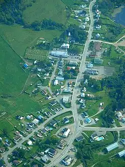 Aerial view of Lac-des-Aigles | |
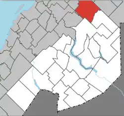 Location within Témiscouata RCM | |
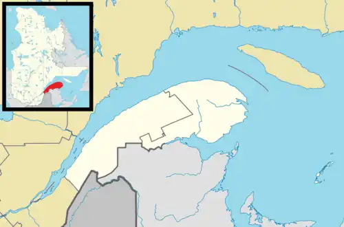 Lac-des-Aigles Location in eastern Quebec | |
| Coordinates: 47°59′19″N 68°40′35″W / 47.9886°N 68.6764°W[1] | |
| Country | |
| Province | |
| Region | Bas-Saint-Laurent |
| RCM | Témiscouata |
| Constituted | July 31, 2024 |
| Government | |
| • Mayor | Pierre Bossé |
| • Federal riding | Côte-du-Sud—Rivière-du-Loup—Kataskomiq—Témiscouata, Rimouski—La Matapédia |
| • Prov. riding | Rivière-du-Loup–Témiscouata |
| Area | |
• Total | 235.02 km2 (90.74 sq mi) |
| • Land | 226.17 km2 (87.32 sq mi) |
| Population | |
• Total | 571 |
| • Density | 2.5/km2 (6/sq mi) |
| • Pop 2016-2021 | |
| • Dwellings | 354 |
| Time zone | UTC−5 (EST) |
| • Summer (DST) | UTC−4 (EDT) |
| Postal code(s) | |
| Area codes | 418 and 581 |
| Highways | |
| Website | www.lacdesaigles.ca/ |
Lac-des-Aigles (French pronunciation: [lak dez‿ɛɡl]) is a city in the Témiscouata Regional County Municipality of the Bas-Saint-Laurent region of Quebec, Canada.[1] The population is 571.[2] Its economy is mainly based on agriculture and forestry. It is located southeast of Rimouski, near Esprit-Saint.[1] It was created on July 31, 2024 by the merger of the municipalities of Lac-des-Aigles and Saint-Guy.[4][5]
History
Settlement of the area began in 1931 with the arrival of land-clearers from Saint-Clément, Saint-Hubert, Bégon and Hocquart, who were short of space. The municipality of Lac-des-Aigles was officially created in 1948.[1] On July 31, 2024, the municipalities of Saint-Guy and Lac-des-Aigles merged to form the town of Lac-des-Aigles.
Geography
Climate
| Climate data for Lac-des-Aigles, Quebec: 320 m (1050 ft) (1981–2010 normals, extremes 1963–2004) | |||||||||||||
|---|---|---|---|---|---|---|---|---|---|---|---|---|---|
| Month | Jan | Feb | Mar | Apr | May | Jun | Jul | Aug | Sep | Oct | Nov | Dec | Year |
| Record high °C (°F) | 11.5 (52.7) |
10.5 (50.9) |
16.7 (62.1) |
26.5 (79.7) |
31.7 (89.1) |
32.0 (89.6) |
33.5 (92.3) |
33.3 (91.9) |
30.0 (86.0) |
25.0 (77.0) |
17.5 (63.5) |
10.5 (50.9) |
33.5 (92.3) |
| Mean daily maximum °C (°F) | −9.7 (14.5) |
−7.3 (18.9) |
−1.5 (29.3) |
6.1 (43.0) |
14.9 (58.8) |
20.3 (68.5) |
22.6 (72.7) |
21.5 (70.7) |
15.8 (60.4) |
8.8 (47.8) |
0.7 (33.3) |
−5.7 (21.7) |
7.2 (45.0) |
| Daily mean °C (°F) | −14.5 (5.9) |
−12.4 (9.7) |
−6.5 (20.3) |
1.4 (34.5) |
9.1 (48.4) |
14.5 (58.1) |
17.0 (62.6) |
15.8 (60.4) |
10.7 (51.3) |
4.5 (40.1) |
−2.9 (26.8) |
−9.9 (14.2) |
2.2 (36.0) |
| Mean daily minimum °C (°F) | −19.4 (−2.9) |
−17.5 (0.5) |
−11.6 (11.1) |
−3.3 (26.1) |
3.3 (37.9) |
8.5 (47.3) |
11.3 (52.3) |
10.1 (50.2) |
5.5 (41.9) |
0.1 (32.2) |
−6.4 (20.5) |
−14.0 (6.8) |
−2.8 (27.0) |
| Record low °C (°F) | −37.0 (−34.6) |
−34.5 (−30.1) |
−31.0 (−23.8) |
−22.5 (−8.5) |
−10.6 (12.9) |
−3.0 (26.6) |
2.2 (36.0) |
−1.5 (29.3) |
−6.7 (19.9) |
−13.3 (8.1) |
−22.5 (−8.5) |
−33.5 (−28.3) |
−37.0 (−34.6) |
| Average precipitation mm (inches) | 99.2 (3.91) |
85.2 (3.35) |
85.7 (3.37) |
94.8 (3.73) |
111.9 (4.41) |
114.2 (4.50) |
132.9 (5.23) |
113.9 (4.48) |
109.8 (4.32) |
113.3 (4.46) |
108.2 (4.26) |
101.8 (4.01) |
1,270.9 (50.03) |
| Average snowfall cm (inches) | 87.4 (34.4) |
74.4 (29.3) |
69.0 (27.2) |
44.2 (17.4) |
6.2 (2.4) |
0.0 (0.0) |
0.0 (0.0) |
0.0 (0.0) |
0.3 (0.1) |
9.3 (3.7) |
51.3 (20.2) |
84.9 (33.4) |
427 (168.1) |
| Average precipitation days (≥ 0.2 mm) | 18.7 | 15.7 | 16.2 | 14.3 | 15.3 | 14.6 | 15.8 | 15.5 | 16.1 | 16.3 | 18.4 | 18.9 | 195.8 |
| Average snowy days (≥ 0.2 cm) | 18.0 | 15.2 | 14.6 | 8.1 | 1.3 | 0.0 | 0.0 | 0.0 | 0.1 | 3.1 | 12.9 | 17.8 | 91.0 |
| Source: Environment Canada[6] | |||||||||||||
Demographics
Population
| 2021 | |
|---|---|
| Population | 495 (-3.3% from 2016) |
| Land area | 86.63 km2 (33.45 sq mi) |
| Population density | 5.7/km2 (15/sq mi) |
| Median age | 53.6 (M: 55.2, F: 53.2) |
| Private dwellings | 289 (total) |
| Median household income | $58,000 |
| 2021 | |
|---|---|
| Population | 76 (40.7% from 2016) |
| Land area | 139.54 km2 (53.88 sq mi) |
| Population density | 0.5/km2 (1.3/sq mi) |
| Median age | 61.2 (M: 60.8, F: 61.2) |
| Private dwellings | 65 (total) |
| Median household income | $n/a |
References: 2021[3]
| Year | Pop. | ±% |
|---|---|---|
| 2016 | 566 | — |
| 2021 | 571 | +0.9% |
Language
| Canada Census Mother Tongue - Lac-des-Aigles, Quebec[7] | ||||||||||||||||||
|---|---|---|---|---|---|---|---|---|---|---|---|---|---|---|---|---|---|---|
| Census | Total | French
|
English
|
French & English
|
Other
| |||||||||||||
| Year | Responses | Count | Trend | Pop % | Count | Trend | Pop % | Count | Trend | Pop % | Count | Trend | Pop % | |||||
2021
|
575
|
565 | 98.3% | 0 | 0.0% | 0 | 0.0% | 0 | 0.0% | |||||||||
2016
|
570
|
560 | n/a | 98.2% | 0 | n/a | 0.0% | 5 | n/a | 0.9% | 0 | n/a | 0.0% | |||||
See also
References
- ^ a b c d "Banque de noms de lieux du Québec: Reference number 33037". toponymie.gouv.qc.ca (in French). Commission de toponymie du Québec.
- ^ a b c "Répertoire des municipalités: Geographic code 13062". www.mamh.gouv.qc.ca (in French). Ministère des Affaires municipales et de l'Habitation.
- ^ a b c d "2021 Community Profiles". 2021 Canadian census. Statistics Canada. February 4, 2022. Retrieved 2024-10-03.
- ^ https://www.publicationsduquebec.gouv.qc.ca/fileadmin/gazette/pdf_encrypte/lois_reglements/2024F/83787.pdf
- ^ "Fusion entre Saint-Guy et Lac-des-Aigles : La nouvelle Ville sera créée à partir du 31 juillet 2024".
- ^ "Saint Guy, Quebec". Canadian Climate Normals 1981–2010 (in English and French). Environment Canada. Retrieved July 26, 2024.
- ^ a b Statistics Canada: 2016, 2021 census
External links
![]() Media related to Lac-des-Aigles at Wikimedia Commons
Media related to Lac-des-Aigles at Wikimedia Commons
Places adjacent to Lac-des-Aigles | |
|---|---|
| Cities & towns | |
|---|---|
| Municipalities | |
| Parishes | |
| |