Lake Louise (Estrie)
| Lac Louise | |
|---|---|
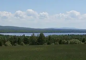 Lake Louise seen from Route 112 near Weedon. Mont Mégantic is visible in the background. | |
 Lac Louise | |
| Location | Les Appalaches Regional County Municipality / Le Granit Regional County Municipality, Quebec |
| Coordinates | 45°43′18″N 71°24′39″W / 45.72167°N 71.41083°W |
| Primary inflows | Saint-François River |
| Primary outflows | Saint-François River |
| Basin countries | Canada |
| Max. length | 3.3 kilometres (2.1 mi) |
| Max. width | 1.75 kilometres (1.09 mi) |
The Lake Louise is a lake in Estrie located in the municipality of Weedon, in the Les Appalaches Regional County Municipality (MRC), in the administrative region of Chaudière-Appalaches, in Quebec, in Canada.
Geography
Lake Louise is located in the Saint-François River valley just upstream of the confluence with the rivière au Saumon. The Saint-François River is its main tributary and outlet; the lake is a widening of the river. The rivière aux Canards also flows into it.
See also
- Saint-Gérard, a municipality
- Weedon, a municipality
- Rivière au Saumon (Le Haut-Saint-François), a watercourse
- Saint-François River, a watercourse
- Rivière au Rat (Weedon), a watercourse
- Les Appalaches Regional County Municipality (MRC)