Lake Sary-Chelek
| Lake Sary-Chelek | |
|---|---|
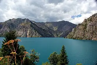 View from the south end of Sary-Chelek looking north | |
 Lake Sary-Chelek  Lake Sary-Chelek | |
| Coordinates | 41°54′N 71°57′E / 41.900°N 71.950°E |
| Type | Mountain lake |
| Primary inflows | Glaciers |
| Primary outflows | Toskool |
| Basin countries | Kyrgyzstan |
| Max. length | 7.5 km (4.7 mi) |
| Max. width | 650 m (2,130 ft) |
| Surface area | 4.92 km2 (1.90 sq mi) |
| Max. depth | 234 m (768 ft) |
| Surface elevation | 1,873 m (6,145 ft) |
Sary-Chelek (also Sarychelek, Kyrgyz: Сарычелек; Russian: Сары-Челек) is a mountain lake located in Sary-Chelek Nature Reserve in Jalal-Abad Province in Western Kyrgyzstan. It is north of Arkyt (the park headquarters) at the eastern end of the Chatkal Range. There are a number of smaller lakes in the area.[1] The lake is 7.5 km (4.7 mi) long and its average width is 650 m (2,130 ft). Its area is 4.92 km2 (1.90 sq mi) and its maximum depth is 234 m (768 ft). It is drained by the river Toskool, a tributary of the Kojata.[2]
References
- ^ "Sary-Chelek Lake: A Distant Beauty". Caravanistan. Retrieved 2020-05-12.
- ^ "Сарычелек көлү" [Sarychelek lake] (PDF). Кыргызстандын Географиясы [Geography of Kyrgyzstan] (in Kyrgyz). Bishkek. 2004. p. 219.
{{cite encyclopedia}}: CS1 maint: location missing publisher (link)
External links
- Sary-Chelek Nature Reserve - Photogallery by Azamat Imanaliev
| |