Langen, Cuxhaven
Langen bei Bremerhaven | |
|---|---|
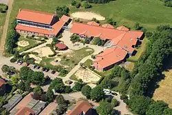 Langen Elementary School in 2012 | |
 Flag _COA.svg.png) Coat of arms | |
Location of Langen bei Bremerhaven | |
 Langen bei Bremerhaven 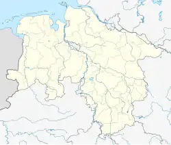 Langen bei Bremerhaven | |
| Coordinates: 53°37′N 8°35′E / 53.617°N 8.583°E | |
| Country | Germany |
| State | Lower Saxony |
| District | Cuxhaven |
| Town | Geestland |
| Area | |
• Total | 121.6 km2 (47.0 sq mi) |
| Elevation | 14 m (46 ft) |
| Population (2013-12-31) | |
• Total | 18,330 |
| • Density | 150/km2 (390/sq mi) |
| Time zone | UTC+01:00 (CET) |
| • Summer (DST) | UTC+02:00 (CEST) |
| Postal codes | 27607 |
| Dialling codes | 04743 |
| Vehicle registration | CUX |
| Website | geestland.eu |
Langen (German pronunciation: [ˈlaŋən] ⓘ) is a town and a former municipality in the district of Cuxhaven, in Lower Saxony, Germany. Since 1 January 2015 it is part of the town Geestland. It is situated approximately 7 km north of the centre of Bremerhaven, and 30 km south of Cuxhaven.
History
Langen belonged to the Prince-Archbishopric of Bremen, established in 1180. In 1648 the Prince-Archbishopric was transformed into the Duchy of Bremen, which was first ruled in personal union by the Swedish Crown - interrupted by a Danish occupation (1712–1715) - and from 1715 on by the Hanoverian Crown. The Kingdom of Hanover incorporated the Duchy in a real union and the Ducal territory became part of the new Stade Region, established in 1823.
.jpg)
References
Wikimedia Commons has media related to Langen bei Bremerhaven.