Larbaâ Nath Irathen District
Larbaâ Nath Irathen District | |
|---|---|
 | |
| Coordinates: 36°38′12.6″N 4°12′12.9″E / 36.636833°N 4.203583°E | |
| Country | |
| Province | Tizi Ouzou Province |
| Chief town | Larbaâ Nath Irathen |
| Area | |
• Total | 33.49 sq mi (86.73 km2) |
| Population (2008) | |
• Total | 46,831 |
| • Density | 1,400/sq mi (540/km2) |
| Time zone | UTC+1 (CET) |
The Larbaâ Nath Irathen is an Algerian administrative district in the Tizi-Ouzou province and the region of Kabylie . Its chief town is located on the common namesake of Larbaâ Nath Irathen.[1][2]
Communes
The district is composed of three communes:
The total population of the district is 46 831 inhabitants[2] for an area of 86.73 km2.
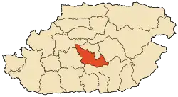
Localisation
District borderings of the Larbaâ Nath Irathen are Tizi Rached, Mekla, Ain El Hammam, Beni Yenni, Beni Douala and Tizi Ouzou.
References
- ^ "Larbaa N'Aït Irathen". OpenStreetMap. OpenStreetMap. Retrieved 3 May 2018.
- ^ a b Découpage Administratif de la Wilaya sur le site officiel de la wilaya de Tizi-Ouzou Archived 2019-07-05 at the Wayback Machine. Accessed 12/02/2011.
.svg.png)