Las Nutrias, New Mexico
Las Nutrias, New Mexico | |
|---|---|
 Las Nutrias | |
| Coordinates: 34°28′11″N 106°46′15″W / 34.46972°N 106.77083°W | |
| Country | United States |
| State | New Mexico |
| County | Socorro |
| Area | |
• Total | 0.97 sq mi (2.50 km2) |
| • Land | 0.97 sq mi (2.50 km2) |
| • Water | 0.00 sq mi (0.00 km2) |
| Elevation | 4,767 ft (1,453 m) |
| Population | |
• Total | 119 |
| • Density | 123.19/sq mi (47.57/km2) |
| Time zone | UTC-7 (Mountain (MST)) |
| • Summer (DST) | UTC-6 (MDT) |
| Area code | 575 |
| GNIS feature ID | 2584134[2] |
Las Nutrias is an unincorporated community and census-designated place in Socorro County, New Mexico, United States. Its population was 149 as of the 2010 census.[4] New Mexico State Road 304 passes through the community.
Geography
According to the U.S. Census Bureau, the community has an area of 0.966 square miles (2.50 km2), all land.[4]
Demographics
| Census | Pop. | Note | %± |
|---|---|---|---|
| 2020 | 119 | — | |
| U.S. Decennial Census[5][3] | |||
Education
Its school district is Belén Consolidated Schools.[6] Belén High School is the district's comprehensive high school.
Gallery
-
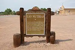 Official Scenic Historic Marker
References
- ^ "ArcGIS REST Services Directory". United States Census Bureau. Retrieved October 12, 2022.
- ^ a b U.S. Geological Survey Geographic Names Information System: Las Nutrias, New Mexico
- ^ a b "Census Population API". United States Census Bureau. Retrieved October 12, 2022.
- ^ a b "2010 Census Gazetteer Files - Places: New Mexico". U.S. Census Bureau. Retrieved December 22, 2016.
- ^ "Census of Population and Housing". Census.gov. Retrieved June 4, 2016.
- ^ "2020 CENSUS - SCHOOL DISTRICT REFERENCE MAP: Socorro County, NM" (PDF). U.S. Census Bureau. Retrieved September 4, 2022.
Municipalities and communities of Socorro County, New Mexico, United States | ||
|---|---|---|
| City |  | |
| Village | ||
| CDPs | ||
| Other communities | ||
| Populated places | ||
| Indian reservations | ||
| Ghost towns | ||
| Footnotes | ‡This populated place also has portions in an adjacent county or counties | |