Laupen District
Laupen District
Amtsbezirk Laupen | |
|---|---|
District | |
 Flag  Coat of arms | |
 | |
| Country | |
| Canton | |
| Capital | Laupen |
| Area | |
• Total | 88 km2 (34 sq mi) |
| Population (2007) | |
• Total | 14,482 |
| • Density | 160/km2 (430/sq mi) |
| Time zone | UTC+1 (CET) |
| • Summer (DST) | UTC+2 (CEST) |
| Municipalities | 11 |
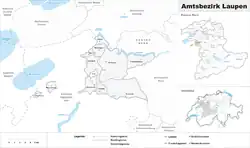
Laupen District is one of the 26 administrative districts in the canton of Bern, Switzerland. Its capital, while having administrative power, was the municipality of Laupen.
From 1 January 2010, the district lost its administrative power while being replaced by the Bern-Mittelland (administrative district), whose administrative centre is Ostermundigen.
Since 2010, it remains therefore a fully recognised district under the law and the Constitution (Art.3 al.2) of the Canton of Berne.
The district has an area of 88 km2 and consisted of 11 municipalities:
| Municipality | Population (Dec 2007)[1] | Area (km2)[1] |
|---|---|---|
| Clavaleyres | 50 | 1.0 |
| Ferenbalm | 1,252 | 9.2 |
| Frauenkappelen | 1,270 | 9.3 |
| Golaten | 307 | 2.8 |
| Gurbrü | 267 | 1.8 |
| Kriechenwil | 398 | 4.8 |
| Laupen | 2,777 | 4.1 |
| Mühleberg | 2,664 | 26.3 |
| Münchenwiler | 409 | 2.5 |
| Neuenegg | 4,678 | 22.0 |
| Wileroltigen | 410 | 4.1 |
The municipalities of Clavaleyres and Münchenwiler are enclaved within the canton of Fribourg.
External links
References
- ^ a b Swiss Federal Statistical Office Archived 2011-09-04 at the Wayback Machine accessed 07-Jul-2009
46°54′00″N 7°14′00″E / 46.9°N 7.23333°E