Laura, Illinois
Laura, Illinois | |
|---|---|
 Laura, Illinois  Laura, Illinois | |
| Coordinates: 40°55′17″N 89°55′35″W / 40.92139°N 89.92639°W | |
| Country | United States |
| State | Illinois |
| County | Peoria |
| Elevation | 728 ft (222 m) |
| Time zone | UTC-6 (Central (CST)) |
| • Summer (DST) | UTC-5 (CDT) |
| ZIP code | 61451 |
| Area code | 309 |
| GNIS feature ID | 411849[1] |
Laura is an unincorporated community in Peoria County, Illinois, United States. Laura is located along a railroad line, 5 miles (8.0 km) east of Williamsfield. Laura has a post office with ZIP code 61451.[2]
History
Laura was platted in the late 1880s, and given the name of the daughter of a railroad official.[3] A post office called Laura has been in operation since 1888.[4]
References
- ^ "Laura". Geographic Names Information System. United States Geological Survey, United States Department of the Interior. Retrieved March 28, 2023.
- ^ ZIP Code Lookup
- ^ Callary, Edward (2009). Place Names of Illinois. University of Illinois Press. p. 194. ISBN 978-0-252-09070-7.
- ^ "Peoria County". Jim Forte Postal History. Retrieved January 16, 2016.
Municipalities and communities of Peoria County, Illinois, United States | ||
|---|---|---|
| Cities | 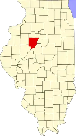 | |
| Villages | ||
| Townships | ||
| CDPs | ||
| Other communities | ||
| Footnotes | ‡This populated place also has portions in an adjacent county or counties | |