Leeward Point Field
Leeward Point Field Leeward Airfield Naval Station Guantanamo Bay | |||||||||||
|---|---|---|---|---|---|---|---|---|---|---|---|
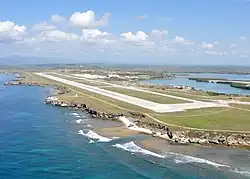 Aerial view, 6 May 2010 | |||||||||||
| Summary | |||||||||||
| Airport type | Military | ||||||||||
| Operator | United States Navy | ||||||||||
| Location | Guantánamo Bay, Cuba | ||||||||||
| Elevation AMSL | 56 ft / 17 m | ||||||||||
| Coordinates | 19°54′23″N 075°12′25″W / 19.90639°N 75.20694°W | ||||||||||
| Map | |||||||||||
.svg.png) MUGM Location in Cuba | |||||||||||
| Runways | |||||||||||
| |||||||||||
Leeward Point Field[1] (IATA: NBW, ICAO: MUGM), also known as Leeward Airfield,[3] is a U.S. military airfield located at Naval Station Guantanamo Bay in Guantánamo Bay, Cuba. On August 18th 1993, a DC-8 freighter crashed in Leeward Point field. All 3 crew members survived.
Facilities
The airport resides at an elevation of 56 ft (17 m) above mean sea level. It has one runway designated 10/28 with an asphalt surface measuring 8,000 ft × 200 ft (2,438 m × 61 m).[1]
References
- ^ a b c "Airport information for MUGM". World Aero Data. Archived from the original on 5 March 2019. Data current as of October 2006. Source: DAFIF.
- ^ Airport information for NBW at Great Circle Mapper. Source: DAFIF (effective October 2006).
- ^ "Photos of Leeward Airfield". Joint Task Force Guantanamo. Archived from the original on 8 April 2010. Retrieved 30 May 2010.
External links
![]() Media related to Aviation at Naval Base Guantanamo Bay at Wikimedia Commons
Media related to Aviation at Naval Base Guantanamo Bay at Wikimedia Commons